Mt. Pleasant, Utah
| Mount Pleasant, Utah | |
|---|---|
| City | |

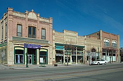
Historic buildings on Mount Pleasant's Main Street
|
|
 Location in Sanpete County and the state of Utah. |
|
| Coordinates: 39°32′35″N 111°27′23″W / 39.54306°N 111.45639°WCoordinates: 39°32′35″N 111°27′23″W / 39.54306°N 111.45639°W | |
| Country | United States |
| State | Utah |
| County | Sanpete |
| Incorporated | 1868 |
| Founded by | Madison Hambleton |
| Area | |
| • Total | 2.8 sq mi (7.3 km2) |
| • Land | 2.8 sq mi (7.3 km2) |
| • Water | 0.0 sq mi (0.0 km2) |
| Elevation | 5,925 ft (1,806 m) |
| Population (2012) | |
| • Total | 3,278 |
| • Density | 1,200/sq mi (450/km2) |
| Time zone | Mountain (MST) (UTC-7) |
| • Summer (DST) | MDT (UTC-6) |
| ZIP code | 84647 |
| Area code(s) | 435 |
| FIPS code | 49-53010 |
| GNIS feature ID | 1430522 |
| Website | Mount Pleasant City Website |
Mount Pleasant is a city in Sanpete County, Utah, in the United States. Mt. Pleasant is known for its 19th-century main street buildings, for being home to Wasatch Academy, and for being the largest city in the northern half of the county. As of the 2010 census, the city population was 3,260.
After taking lumber out of Pleasant Creek Canyon in late 1851, a band of Mormon colonists from Manti led by Madison D. Hambleton returned in the spring of 1852 to establish the Hambleton Settlement near the present site of Mt. Pleasant. During the Walkara (Walker) Indian War, the small group of settlers relocated to Spring Town (Spring City) and later to Manti for protection. The old settlement was burned down by local Native Americans, so when a large colonizing party from Ephraim and Manti returned to the area in 1859, a new, permanent townsite was laid out in its present location—one hundred miles south of Salt Lake City and twenty-two miles northeast of Manti.
Among the founding settlers were Mormon converts from Scandinavia, the United Kingdom, and the eastern United States. By 1880, at which time Mt. Pleasant was the county's largest city, with a population of 2,000, more than 72 percent of its married adults were foreign born. This ethnic diversity had an important impact on village life during the nineteenth and early twentieth centuries. For decades, five languages were commonly spoken in town, creating confusing and sometimes amusing communication problems.
The settlement and development of Mt. Pleasant followed the typical pattern for Mormon towns of the period. A square-shaped townsite was surveyed (eventually containing about 100 city blocks), lots were drawn, and the land was distributed among the population. Under the direction of James Russell Ivie(1802–1866), a fort of adobe walls and log cabins was built. Pleasant Creek ran through the fort and farming was done outside of its walls. Around the time that Ivie was killed in the Ute Black Hawk War, by Indians who had declined to participate in the settlement of the earlier Wakara War, the town had acquired its present name. By the time the final peace treaty with the Indians was signed in Bishop Seeley's house on Main Street in 1872, bringing to an end to this conflict, many settlers had already erected homesteads outside of the fort. Although the townsite is large in scale, the density is relatively low due to the original layout allowing for only four lots per block.
...
Wikipedia
