Mountainburg, Arkansas
| Mountainburg, Arkansas | |
|---|---|
| City | |
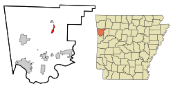
 Location in Crawford County and the state of Arkansas |
|
| Coordinates: 35°38′18″N 94°10′2″W / 35.63833°N 94.16722°WCoordinates: 35°38′18″N 94°10′2″W / 35.63833°N 94.16722°W | |
| Country | United States |
| State | Arkansas |
| County | Crawford |
| Area | |
| • Total | 1.5 sq mi (3.9 km2) |
| • Land | 1.5 sq mi (3.9 km2) |
| • Water | 0 sq mi (0 km2) |
| Elevation | 751 ft (229 m) |
| Population (2010) | |
| • Total | 631 |
| • Density | 419/sq mi (161.6/km2) |
| Time zone | Central (CST) (UTC-6) |
| • Summer (DST) | CDT (UTC-5) |
| ZIP code | 72946 |
| Area code(s) | 479 |
| FIPS code | 05-47300 |
| GNIS feature ID | 0077771 |
Mountainburg is a city in Crawford County, Arkansas, United States. It is part of the Fort Smith, Arkansas-Oklahoma Metropolitan Statistical Area. As of the 2010 census the population was 631.
Mountainburg is located at 35°38′18″N 94°10′2″W / 35.63833°N 94.16722°W (35.638432, -94.167219), along U.S. Route 71, and thrived when this road was the main route in northwest Arkansas. Since the construction of Interstate 540 (now Interstate 49) to the west, it has been a more sleepy community. The city park in downtown Mountainburg has since 1980 hosted two large dinosaur models.
Lake Fort Smith State Park, which is situated on the western side of the 1,400 acres (5.7 km2) Lake Fort Smith, is located 8 miles (13 km) north of Mountainburg.
According to the United States Census Bureau, the city has a total area of 1.5 square miles (3.9 km2), all land.
As of the census of 2000, there were 682 people, 271 households, and 179 families residing in the city. The population density was 478.1 people per square mile (184.1/km²). There were 298 housing units at an average density of 208.9 per square mile (80.5/km²). The racial makeup of the city was 95.45% White, 0.15% Black or African American, 3.08% Native American, 0.15% Pacific Islander, 0.59% from other races, and 0.59% from two or more races. 0.59% of the population were Hispanic or Latino of any race.
...
Wikipedia
