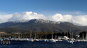
Mount Wellington, Tasmania
| kunanyi / Mount Wellington | |
|---|---|
| Unghbanyahletta or Poorawetter | |

|
|
| Highest point | |
| Elevation | 1,271 m (4,170 ft) |
| Prominence | 693 m (2,274 ft) |
| Isolation | 47.56 km (29.55 mi) |
| Listing | 49th highest mountain of Tasmania |
| Coordinates | 42°53′24″S 147°13′48″E / 42.89000°S 147.23000°ECoordinates: 42°53′24″S 147°13′48″E / 42.89000°S 147.23000°E |
| Geography | |
|
Location in Tasmania
|
|
| Location | South East Tasmania, Australia |
| Parent range | Wellington |
| Geology | |
| Mountain type | Dolerite |
| Climbing | |
| First ascent |
|
| Easiest route | Hike, road |
kunanyi / Mount Wellington (Aboriginal: Unghbanyahletta or Poorawetter) is a mountain in the southeast coastal region of Tasmania, Australia. It is the summit of the Wellington Range and is within the Wellington Park reserve. Located at the foothills of the mountain is much of Tasmania's capital city, Hobart.
The mountain rises to 1,271 metres (4,170 ft) above sea level and is frequently covered by snow, sometimes even in summer, and the lower slopes are thickly forested, but crisscrossed by many walking tracks and a few fire trails. There is also a sealed narrow road to the summit, about 22 kilometres (14 mi) from Hobart central business district. An enclosed lookout near the summit provides spectacular views of the city below and to the east, the Derwent estuary, and also glimpses of the World Heritage Area nearly 100 kilometres (62 mi) west.
From Hobart, the most distinctive feature of Mount Wellington is the cliff of dolerite columns known as the Organ Pipes. It has extensive views of Hobart and is one of the city's biggest tourist destinations.
The low-lying areas and foothills of Mount Wellington were formed by slow geological upsurge when the whole Hobart area was a low-lying cold shallow seabed. The upper reaches of the mountain were formed more violently, as a Sill with a tabular mass of igneous rock that has been intruded laterally between layers of older rock pushing upwards by upsurges of molten rock as the Australian continental shelf tore away from Antarctica, and separated from Gondwana over 40 million years ago. It is often incorrectly considered to be a dormant volcano.
...
Wikipedia

