Mount Townsend
| Mount Townsend | |
|---|---|

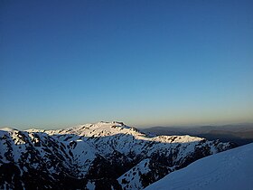
Dawn on Mount Townsend, viewed from Watsons Crags, October 2011.
|
|
| Highest point | |
| Elevation | 2,209 m (7,247 ft) |
| Prominence | 189 m (620 ft) |
| Isolation | 3.71 km (2.31 mi) |
| Listing | Seven Second Summits |
| Coordinates | 36°25′21″S 148°15′32″E / 36.42250°S 148.25889°ECoordinates: 36°25′21″S 148°15′32″E / 36.42250°S 148.25889°E |
| Geography | |
|
Location in New South Wales
|
|
| Location | Snowy Mountains, New South Wales, Australia |
| Parent range | Main Range, Great Dividing Range |
| Topo map | Youngal |
| Climbing | |
| Easiest route | Hike or ski |
Mount Townsend, a mountain in the Main Range of the Great Dividing Range, is located in the Snowy Mountains region of New South Wales, Australia.
With an elevation of 2,209 metres (7,247 ft) above sea level, Mount Townsend is the second-highest peak of mainland Australia. Located in Kosciuszko National Park, the mountain is 3.68 kilometres (2.29 mi) north of Australia's highest mainland peak, Mount Kosciuszko.
Although lower than Mount Kosciuszko, Mount Townsend has a more craggy peak and is arguably more dominant than the relatively round-topped Mount Kosciuszko. Due to ease of climbing Mount Kosciuszko, and the much lower accessibility of Mount Townsend, a tradition has emerged of each person who climbs Mount Townsend carrying a rock from the bottom in their pack, and leaving it at the top, with the goal of making Mount Townsend the taller of the two relatively-similar-in-height peaks.
The names of Mount Townsend and Mount Kosciuszko were originally each attached to the other mountain. Measurements of the peaks originally called by those names showed Kosciuszko to be slightly lower than its neighbour, and the names were transposed by the New South Wales Lands Department in 1892, so that Mount Kosciuszko was renamed Townsend and vice versa.
...
Wikipedia

