Mount Timpanogos Wilderness
| Mount Timpanogos Wilderness | |
|---|---|
|
IUCN category Ib (wilderness area)
|
|

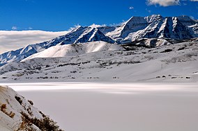
Mount Timpanogos, Winter 2008
|
|
| Location | Utah County, Utah, United States |
| Nearest city | Pleasant Grove, UT |
| Coordinates | 40°23′0″N 111°39′0″W / 40.38333°N 111.65000°WCoordinates: 40°23′0″N 111°39′0″W / 40.38333°N 111.65000°W |
| Area | 10,518 acres (42.56 km2) |
| Established | 1984 |
| Governing body | U.S. Forest Service |
Mount Timpanogos Wilderness is a 10,518-acre (42.56 km2) wilderness area protecting Mount Timpanogos and the surrounding area. It is located in the front range of the Wasatch Mountain Range, between American Fork Canyon on the north and Provo Canyon on the south, within the Uinta-Wasatch-Cache National Forest in the U.S. state of Utah. The wilderness area receives fairly heavy use due to its proximity to the heavily populated cities of Provo and Salt Lake City. It is bordered on the north by Lone Peak Wilderness.
Below the tree line on Mount Timpanogos are vast forests of aspen, Douglas fir, subalpine fir, limber pine, Gambel oak, maple, and chokecherry. Common flowers in the wilderness include forget-me-not, alpine buttercup, bluebell, arnica, larkspur, yarrow, sulfur buckwheat, geranium, and columbine.
Some common wildlife found in Mount Timpanogos Wilderness include Rocky Mountain goat in the Emerald Lake region, as well as mule deer, elk, moose, mountain lion, black bear, and several species of raptor.
...
Wikipedia

