Mount Sutro
| Mount Sutro | |
|---|---|

|
|
| Highest point | |
| Elevation | 911 ft (278 m) NAVD 88 |
| Prominence | 208 ft (63 m) |
| Listing | San Francisco Hill |
| Coordinates | 37°45′30″N 122°27′26″W / 37.7582636°N 122.4571935°WCoordinates: 37°45′30″N 122°27′26″W / 37.7582636°N 122.4571935°W |
| Geography | |
| Location | San Francisco, California, U.S. |
| Climbing | |
| Easiest route | Hike, Paved Road |
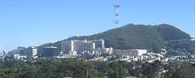
Mount Sutro is a hill in central San Francisco, California. It was originally named Mount Parnassus.
The low mountain is 909 feet (277 m) in elevation. Mount Sutro is one of the many named hills within San Francisco, and among its original "Seven Hills".
Most of Mount Sutro is owned by the University of California, San Francisco (UCSF). A 61-acre (25 ha) parcel, including the summit, is protected as the Mount Sutro Open Space Reserve by UCSF, and open to the public.
Sutro Tower, a large television and radio broadcasting tower for the San Francisco Bay Area and very visible City landmark is not on Mount Sutro. It stands on a lower hill to the south between it and Twin Peaks.
Mount Sutro has been covered by a dense forest, with about 80% being introduced eucalyptus trees, that was planted in the late 19th century. The older trees are now over 100 feet (30 m) tall. The mountain is within San Francisco's fog belt, receiving fog throughout the summer. The tall trees precipitate the fog, with the moisture being absorbed by the duff and tree roots, and the forest remains damp through the summer months. It receives some 30 to 40% of its moisture from fog drip. There is a dense understory of non-native Himalayan blackberry (Rubus armeniacus) and several other plants. The forest provides habitat for a number of bird species, including great horned owls and various woodpeckers. Over thirty species were recorded in a single morning of bird watching.
The 19-acre (7.7 ha) city-owned portion of Mount Sutro and the eucalyptus forest, called the Interior Green Belt, is contiguous with the UCSF-owned 61 acres (25 ha) Mount Sutro Open Space Reserve portion. The forest is bounded on the north by the UCSF Medical Center and the UCSF Stem-cell Research Building; on the west by the Sunset District; on the south by the Forest Knolls neighborhood, built in the late 1950s on cleared forest land; and on the east by the Cole Valley neighborhood.
...
Wikipedia
