Mount Sorrel
| Battle of Mont Sorrel | |||||||
|---|---|---|---|---|---|---|---|
| Part of the Ypres Salient along the Western Front of World War I | |||||||
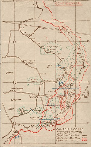
 Restored battlefield map of positions occupied on 4 June 1916 |
|||||||
|
|||||||
| Belligerents | |||||||
|
|
|||||||
| Commanders and leaders | |||||||
|
|
|
||||||
| Strength | |||||||
| 2 Canadian divisions 1 British division |
3 divisions | ||||||
| Casualties and losses | |||||||
| c. 8,000 | 5,765 | ||||||
The Battle of Mont Sorrel (Battle of Mount Sorrel, Battle of Hill 62) was a local operation in World War I by three divisions of the British Second Army and three divisions of the German Fourth Army in the Ypres Salient, near Ypres, Belgium, from 2 to 14 June 1916.
In an effort to pull British resources from the observed build-up in the Somme, the XIII (Royal Württemberg) Corps and the 117th Infantry Division attacked an arc of high ground positions, defended by the Canadian Corps. The German forces initially captured the heights at Mount Sorrel and Tor Top before entrenching on the far slope of the ridge. Following a number attacks and counterattacks, two divisions of the Canadian Corps, supported by the 20th Light Division and Second Army siege and howitzer battery groups, recaptured the majority of their former positions.
Located in the Ypres Salient, 3 kilometres (1.9 mi) east of Ypres, Belgium, the Battle of Mount Sorrel took place along a ridge between Hooge and Zwarteleen. The crest line of Mount Sorrel, nearby Tor Top (Hill 62) and Hill 61 rose approximately 30 metres (98 ft) higher than the shallow ground at Zillebeke, affording the occupying force excellent observation over the salient, the town of Ypres and approach routes. The peaks were the only portion of the crest of the Ypres ridge which remained in Allied hands.
...
Wikipedia
