Mount Seymour
| Mount Seymour | |
|---|---|

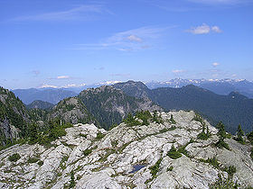
View from First Pump Peak, one of Seymour's sub peaks.
|
|
| Highest point | |
| Elevation | 1,449 m (4,754 ft) |
| Prominence | 453 m (1,486 ft) |
| Coordinates | 49°23′36″N 122°56′40″W / 49.39333°N 122.94444°WCoordinates: 49°23′36″N 122°56′40″W / 49.39333°N 122.94444°W |
| Geography | |
|
Location in Metro Vancouver
|
|
| Location | British Columbia, Canada |
| Parent range | Fannin Range |
| Topo map | NTS 92G/07 |
| Climbing | |
| First ascent | 1908 C. Chapman; B. Darling; W. Gray; G. Harrow; R. Mills |
| Mount Seymour Ski Area | |
|---|---|
| Location | British Columbia, Canada |
| Nearest city | North Vancouver |
| Coordinates | 49°23′46″N 122°56′40″W / 49.39611°N 122.94444°W |
| Vertical | 330 m (1,083 ft) |
| Top elevation | 1,265 m (4,150 ft) |
| Base elevation | 935 m (3,068 ft) |
| Skiable area | 200 acres |
| Runs | 23 total 22% beginner 61% intermediate 17% expert |
| Longest run | 1.6 km (1 mi) |
| Lift system | 5 total 1 high speed detachable quad 2 double chairlifts 2 magic carpets |
| Snowfall | 1,200 cm (472 in) |
| Website | Mt. Seymour |
Mount Seymour is a mountain located in Mount Seymour Provincial Park in the District of North Vancouver, British Columbia, Canada. It is a part of the North Shore Mountains, rising to the north from the shores of Burrard Inlet and Indian Arm to a summit of 1,449 m (4,754 ft) above the Indian River and Deep Cove neighbourhoods. Mount Seymour is most commonly identified for its ski area of the same name, and as a popular hiking area. It is named in honour of Frederick Seymour, second governor of the Colony of British Columbia. The name is used to refer to the ridge although the main summit is one of several, and is also known as Third Pump Peak.
The mountain opened for skiing in 1938 under the ownership of the Swedish emigrant, Harald Enqvist, with a cafeteria and ski rental. A few years later, in 1949, the Government of British Columbia bought the ski area. The Government did not have the experience to run a ski area, so, they issued Mr. Enqvist the first Park Use Permit to operate the area. When the permit expired in 1951, the government found a concessionaire, who was put in charge of running the lifts, ski school and cafeteria. The name Enqvist was later spelled Enquist giving name to "The Enquist Lodge" and "Enquist Tube Park" among other facilities. The government retained overall ownership until 1984, when it privatized its operation as part of a cost-cutting measure.
The ski area has been run by the wood family since 1984. They installed the Lodge chairlift in 1986 and the Brockton chairlift in the early 1990s. Starting in the 2010s, the mountain has been more aggressively upgraded. The original Mystery Peak chairlift was removed in 2012 and replaced with a high-speed quad, while the Goldie rope tow was replaced with a magic carpet.
...
Wikipedia

