Mount Sentinel
| Mount Sentinel | |
|---|---|

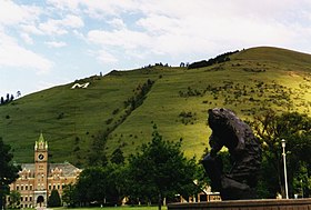
Mount Sentinel with University of Montana Campus in the foreground.
|
|
| Highest point | |
| Elevation | 5,158 ft (1,572 m) |
| Prominence | 118 ft (36 m) |
| Coordinates | 46°51′09″N 113°57′48″W / 46.85250°N 113.96333°WCoordinates: 46°51′09″N 113°57′48″W / 46.85250°N 113.96333°W |
| Geography | |
|
|
|
| Parent range | Sapphire Mountains |
| Topo map | USGS Southeast Missoula |
Mount Sentinel, originally known as "Mount Woody," is a small mountain located to the east of the University of Montana in Missoula, Mont. At a height of 1,958 feet and an elevation of 5,158 feet (1,572 m), Mount Sentinel also features the hillside letter "M", a large concrete structure 620 feet (189 m) up its western face.
The University of Montana first received land on Mount Sentinel in 1902 when the Northern Pacific Railroad Company donated 40 acres at the foot and up the slope of the mountain. The U.S. Congress later turned over many acres of Mount Sentinel so that campus extended up the slope to the crest of the mountain, making the University of Montana the only university in the nation to own a mountain. In 2000, the city of Missoula also purchased 475 acres along the face of Mount Sentinel.
Between 15,000 and 13,000 years ago, a Pleistocene Ice Age glacier moved through the Purcell Trench in northern Idaho, damming the Clark Fork River. This glacial dam created Glacial Lake Missoula, a lake larger than Lake Erie and Lake Ontario combined. As the lake continued to grow, pressure increased on the glacial dam, ultimately causing the dam to fail. Water from the lake rushed westward at speeds between 30 and 50 miles per hour across Montana, Idaho, and Washington. The violent flow created by the draining of Glacial Lake Missoula left shoreline marks that are still visible on the face of Mount Sentinel and Mount Jumbo, a neighboring mountain to the north.
The first trail up Mount Sentinel to the area that the "M" would later occupy was cut by forestry students in 1908. In 1909, the junior class constructed the first "M" at the top of that trail with whitewashed rocks. In 1912, the freshman class constructed a small white "M" of wood. This "M" stood upright on the face of the mountain and cost $18 to build. The wooden "M" was destroyed by wind in 1914, replaced, and then wrecked by wind again. In 1915, a new "M" made of whitewashed rocks was constructed 200 feet above the original "M" site. A concrete "M" measuring 125-by-100-feet was built in 1968 at a cost of $4,328. The concrete structure was built because it was no longer feasible to maintain the old, rock "M". This concrete "M" is still located on Mt. Sentinel today.
...
Wikipedia

