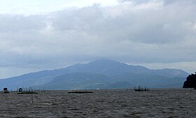
Mount Sembrano
| Mount Sembrano | |
|---|---|

The mountain as seen from the shores of Laguna de Bay in Los Baños, Laguna
|
|
| Highest point | |
| Elevation | 745 m (2,444 ft) |
| Coordinates | 14°23′00″N 121°21′57″E / 14.38333°N 121.36583°ECoordinates: 14°23′00″N 121°21′57″E / 14.38333°N 121.36583°E |
| Geography | |
| Location | Luzon |
| Country | Philippines |
| Region | CALABARZON |
| Provinces | |
| Municipalities | |
| Geology | |
| Mountain type | Extinct volcano with a solfataric field on its southern tip |
| Last eruption | 27,000-29,000 years ago |
| Climbing | |
| Easiest route | from Brgy. Malaya in Pililla, Rizal |
Mount Sembrano is a mountain located between Rizal and Laguna of the CALABARZON region in the Philippines. Mt. Sembrano is situated about 60 kilometres (37 mi) east by road from the capital city of Manila.
Mount Sembrano lies between the boundaries of the towns of Jalajala and Pililla in Rizal province and the town of Pakil in Laguna. The mountain sits at the helm of Jalajala peninsula along the shore of Laguna de Bay and is surrounded by the lake on three sides. Along with Talim Island, the mountain forms the southeastern rim of the Laguna Caldera.
Once a haven of New People's Army insurgents, the mountain is now a popular hiking destination offering a commanding view of Laguna de Bay, Talim Island, and the Tagalog provinces of Rizal and Laguna.Mount Susong Dalaga (Maiden's breast Mountain), a conical hill resembling the female breast which is the highest peak of neighboring Talim Island, is best observed from Mt. Sembrano. Other mountains visible from the summit are Mount Banahaw, Mount Makiling and the Sierra Madre Mountains.
The most common starting point for the climb up the mountain is from the Barangay Hall in Brgy. Malaya in Pililla, Rizal where climbers must register themselves. The hike to the grassy summit which is fully exposed to the sun, takes about three to four hours. Another trail starts from the Laguna side of the mountain in the town of Pakil, but is rarely used.
...
Wikipedia

