Mount Roskill
| Mount Roskill / Mt Roskill | |
|---|---|

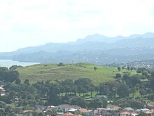
Mount Roskill from Big King. The Waitakere Ranges in the background.
|
|

Location of Mount Roskill in Auckland.
|
|
| Basic information | |
| Local authority | Auckland Council |
| Surrounds | |
| North | Balmoral, Eden Valley |
| Northeast | Mount Eden |
| East | Three Kings |
| Southeast | Hillsborough |
| South | Waikowhai |
| Southwest | Lynfield |
| West | New Windsor, New Zealand, Wesley |
| Northwest | Owairaka, Sandringham |
| Dominion Road School | |
|---|---|
| Address | |
| Quest Terrace, Mt Roskill, Auckland, New Zealand |
|
| Coordinates | 36°54′16″S 174°44′36″E / 36.904472°S 174.743460°E |
| Information | |
| Type | State, Co-educational, Primary |
| Motto | Onward and Upward |
| Ministry of Education Institution no. | 1261 |
| Principal | Marian Caulfield |
| School roll | 356(February 2017) |
| Socio-economic decile | 3 |
| Website | dominionrd.school.nz |
Mount Roskill is both a volcanic peak and the suburban area in the city of Auckland, New Zealand.
The mountain formed as a result of volcanic activity some 20,000 years ago. Its peak, located in present-day Winstone Park towards the southwest end of the suburb, is 110 metres in height - one of the many extinct cones which dot the isthmus of Auckland, all of which form part of the Auckland volcanic field. The scoria cone was built by fire-fountaining from two craters. Lava flowed from the base of the cone to the north and to the northwest. It was the site of a pā, and was known as Puketāpapa ("the flat-topped mountain" in Te Reo Māori) and as Pukewīwī. The main southern crater was excavated in 1961-1962 and filled with a water-supply reservoir. The reservoir is no longer in active service, and is only maintained as an emergency supply.
Since 2009 the extension of State Highway 20 has passed close to the cone. The effects of the new motorway on the cone had been the subject of significant discussion, and a major mitigation package had been proposed to reduce the impact of the motorway (and the continuation of the Waikaraka Cycleway that runs parallel to it).
The funding of this mitigation and the missing cycleway section was briefly in doubt in 2009, when a cost blowout to $2 million was criticised after Council had set aside $1.6 million. Cycling advocates from Cycle Action Auckland, the Mount Roskill Community Board Chairman Richard Barter and Councillor John Lister however noted various elements unrelated to the cycleway that had driven up the cost, such as a toilet block, bluestone walls, extensive landscaping and artwork, much of it related to Winstone Park itself, or the effects of the motorway. The cycle-path section itself was priced at only $300,000. The path section was finished after six months of construction work and it (and the park facilities) opened to the public on 25 July 2010.
The suburb, named after the Mount, is located seven kilometres to the south of the city centre, and is surrounded by the neighbouring suburbs of Three Kings, Sandringham, Wesley, Hillsborough and Mount Albert. The Mount Roskill shops are located at the intersection of Mount Albert and Dominion Roads.
...
Wikipedia
