Mount Eden
| Mount Eden | |
|---|---|

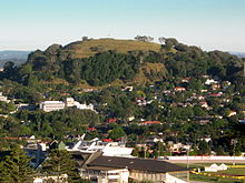
Mount Eden looming high above suburban Epsom viewed from Maungakiekie / One Tree Hill
|
|

Location in Auckland
|
|
| Basic information | |
| Local authority | Auckland Council |
| Date established | 1870s |
| Population | 10,833 (2006) |
| Facilities | |
| Train station(s) | Mount Eden Train Station |
| Surrounds | |
| North | Eden Terrace, Grafton |
| Northeast | Newmarket |
| Southeast | Epsom, Greenwoods Corner |
| South | Three Kings |
| Southwest | Mount Albert |
| West | Sandringham |
| Northwest | Eden Valley, Kingsland |
Mount Eden is a suburb in Auckland, New Zealand whose name honours George Eden, 1st Earl of Auckland. It is 4 kilometres (2.5 mi) south of the Central Business District (CBD). Mt Eden Road winds its way around the side of Mount Eden Domain and continues to weave back and forth as it descends into the valley; it runs south from Eden Terrace to Three Kings. Mt Eden village centre is located roughly between Valley Road and Grange Road. The domain is accessible on foot from many of the surrounding streets, and by vehicle from Mt Eden Road. The central focus of the suburb is Maungawhau / Mount Eden, a dormant volcano whose summit is the highest natural point on the Auckland isthmus.
In pre-European times Mount Eden was utilised as a fortified hill pa by various Māori tribes. The pa is thought to have been abandoned around 1700 AD after conflict between the resident Waiohua people and the Hauraki tribes The earth ramparts and terraces from this period contribute to the distinctive outline of the hill today.
The area directly around the hill consists of very fertile free-draining soil mixed with a great deal of volcanic debris in the form of scoria rocks. When Europeans came to the area, they found a landscape devoid of large trees, as anything of any size had been cut down by the Maori for various uses, such as the timber palisades of the pa. The land was covered with bracken, flax and Manuka trees, with whau shrubs growing on the hill. The Europeans cleared the land of the scoria rocks and made fences with them to define property boundaries. This resulted in a landscape reminiscent of Ireland or the Scottish lowlands. These scoria walls are still a feature of the suburb today.
Initially the land was utilised for farms, but from quite early on the area hosted country residences of professionals and business people from Auckland. Most of the farm land was subdivided into large suburban plots between 1870 and 1875, and the principal roads were formed by the Crown. Mt Eden's first school opened in 1877 on the corner of Mt Eden and Valley roads. In 1879 the mountain was officially protected as a public reserve. The tea kiosk on the slope of Mt Eden was built in 1927.
...
Wikipedia
