Mount Pisgah (mountain in North Carolina)
| Mount Pisgah | |
|---|---|

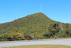
View of Mount Pisgah from the Blue Ridge Parkway, October 2016
|
|
| Highest point | |
| Elevation | 5,721 ft (1,744 m) |
| Coordinates | 35°25′32″N 82°45′25″W / 35.4255°N 82.7569°WCoordinates: 35°25′32″N 82°45′25″W / 35.4255°N 82.7569°W |
| Geography | |
| Location | Buncombe / Haywood counties, North Carolina, U.S. |
| Parent range | Appalachian Mountains |
| Topo map | USGS Cruso |
| Climbing | |
| Easiest route | Hike |
Mount Pisgah is a mountain in the Appalachian Mountain Range and part of the Blue Ridge Mountains of North Carolina, United States. The mountain's height is 5,721 feet (1,744 m) above sea level, and it sits approximately 15 miles (24 kilometers) southwest of Asheville, near the crossing of the boundaries of Buncombe, Haywood, Henderson and Transylvania counties. It is located on the border of Buncombe and Haywood counties, close to the point where Henderson and Transylvania meet them, but not actually within the latter two counties. The mountain is easily accessible via a hiking trail from the Blue Ridge Parkway, near the Pisgah Inn.
The prominent tower in the picture at the crest of Mount Pisgah, on what is known as Pisgah Ledge, is a 339-foot-tall (103 m) television broadcast tower owned by Chesapeake Television, Incorporated, doing business as the Sinclair Broadcast Group, licensee of WLOS TV 13.x, transmitting on VHF channel 13, from nearby Asheville, North Carolina. It is the highest television antenna east of the Mississippi River, at 2,814 feet (858 m) above the surrounding valley floor, and 6,023 feet (1,836 m) above mean sea level, according to the Federal Communications Commission. Co-located on the tower is WUNF-TV 33.x on UHF channel 25, WKSF FM 99.9, and WXL56 on 162.400MHz from the Greenville/Spartanburg office of the National Weather Service. From this location, the stations cover the media market. Due to the terrain shielding of the surrounding mountains, and the much lower and flatter Piedmont (and therefore much greater height above average terrain) toward the southeast, the stations actually cover much more of South Carolina than they do North Carolina.
...
Wikipedia
