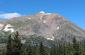
Mount Lincoln (Colorado)
| Mount Lincoln | |
|---|---|

View of Mt Lincoln from Colorado State Highway 9
|
|
| Highest point | |
| Elevation | 14,293 ft (4356.5 m) NAVD88 |
| Prominence | 3862 ft (1177 m) |
| Isolation | 22.5 mi (36.2 km) |
| Listing | |
| Coordinates | 39°21′05″N 106°06′42″W / 39.3514512°N 106.1115668°WCoordinates: 39°21′05″N 106°06′42″W / 39.3514512°N 106.1115668°W |
| Geography | |
| Location | High point of Park County, Colorado, United States |
| Parent range |
Highest summit of the Mosquito Range |
| Topo map |
USGS 7.5' topographic map Alma, Colorado |
| Climbing | |
| Easiest route | hike |
Mount Lincoln is the eighth-highest summit of the Rocky Mountains of North America and the U.S. state of Colorado. The prominent 14,293-foot (4356.5 m) fourteener is the highest summit of the Mosquito Range and the eleventh-highest summit in the contiguous United States. Mount Lincoln is located in Pike National Forest, 5.2 miles (8.3 km) north-northwest (bearing 332°) of the Town of Alma in Park County, Colorado, United States. The summit of Mount Lincoln is the highest point in Park County and the entire drainage basin of the Missouri River. The mountain was named in honor of Abraham Lincoln, 16th President of the United States.
Mount Lincoln is typically climbed from the east, starting at the Roberts Road Trailhead off of Colorado Highway 9. Multiple routes ascend from this trailhead, all starting along the Quartzville Creek Jeep Trail. The shortest route climbs 3,000 ft (900 m) in 3.5 mi (5.6 km), with the upper part of the route involving hiking on broken granite and shale.
Many climbers attempt to combine the summit of Lincoln with those of Bross and Democrat in one climb.
Silver was discovered here in 1874.
...
Wikipedia

