Mount Jackson, Virginia
| Mount Jackson, Virginia | |
|---|---|
| Town | |

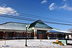
Mount Jackson Town Hall, Visitor Center, Museum and Library in December 2013.
|
|
 Location of Mount Jackson, Virginia |
|
| Coordinates: 38°45′00″N 78°38′15″W / 38.75000°N 78.63750°W | |
| Country | United States |
| State | Virginia |
| County | Shenandoah |
| Area | |
| • Total | 1.2 sq mi (3.2 km2) |
| • Land | 1.2 sq mi (3.2 km2) |
| • Water | 0.0 sq mi (0.0 km2) |
| Elevation | 909 ft (277 m) |
| Population (2010) | |
| • Total | 1,994 |
| • Density | 1,700/sq mi (620/km2) |
| Time zone | Eastern (EST) (UTC-5) |
| • Summer (DST) | EDT (UTC-4) |
| ZIP code | 22842 |
| Area code(s) | 540 |
| FIPS code | 51-53992 |
| GNIS feature ID | 1498404 |
Mount Jackson is a town in Shenandoah County, Virginia, United States. The population was 1,994 at the 2010 census.
Mount Jackson is easily identified from I-81 exit 273 by the water tower painted as a basket of apples, which was recently repainted.
The Bauserman Farm, Meems Bottom Covered Bridge, J.W.R. Moore House, and Mount Jackson Historic District are listed on the National Register of Historic Places.
Mount Jackson is in the southern part of Shenandoah County, Virginia at 38°45′00″N 78°38′15″W / 38.749950°N 78.637638°WCoordinates: 38°45′00″N 78°38′15″W / 38.749950°N 78.637638°W (38.749950, -78.637638). The town is located just to the west of Short Mountain, a prominent peak of the Massanutten Mountain Ridge.
...
Wikipedia
