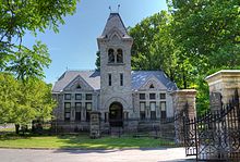
Mount Hope Cemetery, Rochester

Gate House of Mount Hope Cemetery
|
|
| Details | |
|---|---|
| Established | 1838 |
| Location | Rochester, New York |
| Country | USA |
| Coordinates | 43°07′42″N 77°37′17″W / 43.12833°N 77.62139°W |
| Type | public |
| Owned by | City of Rochester |
| Size | 196 acres (79 ha) |
| No. of graves | 350,000 |
| Find a Grave | Mount Hope Cemetery |
| The Political Graveyard | Mount Hope Cemetery |
Mount Hope Cemetery in Rochester, New York, founded in 1838, is one of the United States' first municipal rural cemeteries. Situated on 196 acres (793,000 m²) (0.3 square miles) of land adjacent to the University of Rochester on Mount Hope Avenue, the cemetery is the permanent resting place of over 350,000 people. The annual growth rate of this cemetery is 500-600 burials per year.
Mount Hope also contains the ruins of a now outdated catacomb system, most notably with its sealed entrance on the east-facing drumlin upon entering the cemetery from the north. Its alternative entrance (also sealed) can be found in the Sunken Garden of Warner Castle across Mt. Hope Avenue. In 2010, G. Gotham Smith shot a segment of the feature film 3.14.. around the pond and catacombs.
The cemetery hosts the sculpture Defenders of the Flag, a Civil War monument made in 1908 by the American sculptor Sally James Farnham.
About 12,000 to 14,000 years ago, Mount Hope was covered with ice one to two miles thick. As the glacier receded, cracks appeared in the ice, and these crevasses became rivers of water and gravel. When the miles-high ice sheets finally melted, these river beds were left as ridges created from all the rock and rubble that had been deposited by the flowing river. In geological terms, these ridges are called eskers. One such esker snakes its way through much of Mount Hope Cemetery.
The Seneca Indians used the Mount Hope esker as a trail from the Bristol Hills south of Rochester to Lake Ontario on the city's northern border. For the Senecas, it provided a continuous high path through the moraine and visibility of valleys around them. Today, this esker is a principal vehicular lane through the cemetery and is called Indian Trail Avenue.
...
Wikipedia
