Mount Guyot (Great Smoky Mountains)
| Mount Guyot | |
|---|---|

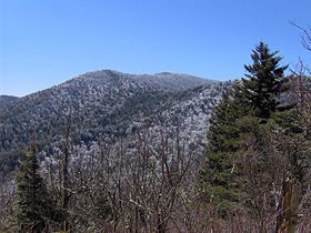
Mt. Guyot, looking south from the Appalachian Trail
|
|
| Highest point | |
| Elevation | 6,621 ft (2,018 m) |
| Prominence | 1,581 ft (482 m) |
| Coordinates | 35°42′18″N 83°15′27″W / 35.705°N 83.2575°WCoordinates: 35°42′18″N 83°15′27″W / 35.705°N 83.2575°W |
| Geography | |
| Location | Haywood County, North Carolina / Sevier County, Tennessee, US |
| Parent range | Great Smoky Mountains |
| Topo map | USGS Mount Guyot |
| Climbing | |
| Easiest route | Snake Den Ridge Trail + Appalachian Trail + bushwhack |
Mount Guyot is a mountain in the eastern Great Smoky Mountains, located in the southeastern United States. At 6,621 feet (2,018 m) above sea level, Guyot is the fourth-highest summit in the eastern U.S., and the second-highest in the Great Smoky Mountains National Park[1]. While the mountain is remote, the Appalachian Trail crosses its south slope, passing to within 1,000 feet (300 m) of the summit.
Mount Guyot lies on the Tennessee-North Carolina border, between Sevier County and Haywood County. There are two peaks atop the mountain, appx. one-half mile apart, with the southwestern peak being the true summit. The mountain rises 3,600 feet (1,100 m) above its eastern base near Walnut Bottom [2] and 4,000 feet (1,200 m) above its western base near Greenbrier Cove. Ramsey Cascades, one of the park's most spectacular waterfalls, spills down a sandstone cliff near the bottom of Guyot's western slope.
A dense stand of Southern Appalachian spruce-fir forest coats the summit and upper slopes of Guyot. Human settlement never expanded deep into the eastern Smokies, so the area around Guyot and adjacent peaks suffered substantially less disturbance than the mountains in the western or central parts of the range. A long hike and a challenging bushwhack are required to reach the summit.
Mount Guyot is composed of Precambrian rocks of the Ocoee Supergroup, formed from ocean sediments approximately one billion years ago. The mountain is underlain by Thunderhead sandstone, which is common throughout the Smokies. The Thunderhead sandstone was thrust over Roaring Fork sandstone several hundred million years ago. Mt. Guyot itself was formed during the Appalachian orogeny over 200 million years ago, when the North American and African plates collided, thrusting the rock upward.
...
Wikipedia
