Mount Geryon
| Mount Geryon | |
|---|---|

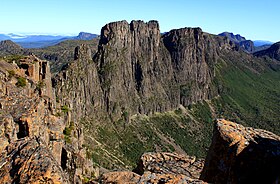
The east face of Mount Geryon, as seen from the top of The Acropolis
|
|
| Highest point | |
| Elevation | 1,516 m (4,974 ft) |
| Prominence | 580 m (1,900 ft) |
| Isolation | 6.57 km (4.08 mi) |
| Listing | 12th/15th highest mountain in Tasmania |
| Coordinates | 41°55′12″S 146°03′00″E / 41.92000°S 146.05000°ECoordinates: 41°55′12″S 146°03′00″E / 41.92000°S 146.05000°E |
| Geography | |
|
Location in Tasmania
|
|
| Location | Central Highlands of Tasmania, Australia |
| Parent range | Du Cane |
| Geology | |
| Age of rock | Jurassic |
| Mountain type | Dolomite |
Mount Geryon is a mountain in the Central Highlands region of the Australian state of Tasmania. The mountain is part of the Du Cane Range and is situated within the Cradle Mountain-Lake St Clair National Park.
With two peaks, Mount Geryon North has an elevation of 1,516 metres (4,974 feet) above sea level and is the twelfth-highest mountain in Tasmania. Mount Geryon South, with an elevation of 1,509 metres (4,951 ft) above sea level, is the state's fifteenth-highest peak.
The mountain is a major feature of the national park, and is a popular venue with bushwalkers and mountain climbers. It has more than 40 ascent routes for climbers, some of which are over 300 metres (980 ft) in height; however, it is the impressive east face at 500 metres (1,600 ft) in height for which Mount Geryon is most popular.
There is a famous nearby tarn which is known as the Pool of Memories.
...
Wikipedia

