Mount Gambier, South Australia
|
Mount Gambier South Australia |
|||||||
|---|---|---|---|---|---|---|---|

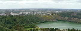
View north across Valley Lake and Marist Park to the eastern urban area of Mount Gambier from Centenary Tower
|
|||||||
| Coordinates | 37°49′46″S 140°46′58″E / 37.82944°S 140.78278°ECoordinates: 37°49′46″S 140°46′58″E / 37.82944°S 140.78278°E | ||||||
| Population | 28,929 (2015) (47th) | ||||||
| • Density | 149.66/km2 (387.61/sq mi) | ||||||
| Established | 1854 | ||||||
| Postcode(s) | 5290, 5291 | ||||||
| Area | 193.3 km2 (74.6 sq mi) (2011 urban) | ||||||
| Time zone | ACST (UTC+9:30) | ||||||
| • Summer (DST) | ACDT (UTC+10:30) | ||||||
| Location | |||||||
| LGA(s) | |||||||
| County | Grey | ||||||
| State electorate(s) | Mount Gambier | ||||||
| Federal Division(s) | Barker | ||||||
|
|||||||
Mount Gambier is the second most populous city in South Australia with an estimated urban population of 28,929. The city is located on the slopes of Mount Gambier (volcano) in the south east of the state, about 450 kilometres (280 mi) south-east of the capital Adelaide and just 17 kilometres (11 mi) from the Victorian border, it is the most important settlement in the Limestone Coast region and the seat of government for both the City of Mount Gambier and the District Council of Grant.
The peak of the dormant volcano was the first place in South Australia named by European explorers. It was sighted in 1800 by Lieutenant James Grant from the survey brig, HMS Lady Nelson, and named for Lord James Gambier, Admiral of the Fleet. The peak is marked by Centenary Tower, built in 1901 to commemorate the first sighting, and at 192 metres (630 ft) above sea level the landmark is the city's highest point.
The city is known for its geographical features, particularly its volcanic and limestone features, most notably its Blue Lake, parks and gardens, caves and sinkholes.
Before European settlement, the Buandig (or Boandik) people were the original Aboriginal inhabitants of the area. They called it 'ereng balam' or 'egree belum', meaning 'home of the eagle hawk'.
The peak of the dormant Mount Gambier crater was sighted in 1800 by Lieutenant James Grant from the survey brig, HMS Lady Nelson, and named for Lord James Gambier, Admiral of the Fleet.
The Henty brothers who owned large holdings in Portland, Western Victoria, laid claim to the land but were forced to retreat when the lands were granted to Evelyn Sturt, the brother of the explorer Charles Sturt. Industries soon began to appear. The Post Office opened on 22 September 1846, John Byng built the Mount Gambier Hotel in 1847, and Dr Edward Wehl arrived in 1849 to begin a flour-milling operation.
...
Wikipedia

