Mount Edgecumbe (Alaska)
| Mount Edgecumbe | |
|---|---|

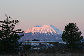
Mount Edgecumbe in December 2004.
|
|
| Highest point | |
| Elevation | 3,201 ft (976 m) |
| Prominence | 3,201 ft (976 m) |
| Coordinates | 57°03′05″N 135°45′31″W / 57.05139°N 135.75861°WCoordinates: 57°03′05″N 135°45′31″W / 57.05139°N 135.75861°W |
| Geography | |
| Location | Kruzof Island, Sitka City and Borough, Alaska, U.S. |
| Topo map | USGS Sitka A-6 |
| Geology | |
| Age of rock | < 600,000 yr |
| Mountain type | Dacite stratovolcano |
| Last eruption | 2220 BCE ± 100 years |
| Climbing | |
| First ascent | 1805 by Urey Lisianski |
| Easiest route | Hike |
Mount Edgecumbe is a dormant volcano located at the southern end of Kruzof Island, Alaska. The volcano is about 16 km (10 miles) east of the Queen Charlotte Fault that separates the North American and Pacific Plates, and is the highest point in the Mount Edgecumbe volcanic field, an area of about 260 km² (162 sq miles) on Kruzov Island that also includes Crater Ridge and Shell Mountain.
The indigenous Tlingit people considered the mountain to be sacred. In the Tlingit language, the mountain is called L’ux, which means "to flash" or "blinking," purportedly because the Tlingit people first discovered it while it was smoking or erupting.
On 16 August 1775, Spanish explorer Juan de la Bodega named the mountain Montaña de San Jacinto to honor Saint Hyacinth, whose feast day is celebrated on 17 August. Captain James Cook passed the mountain on 2 May 1778 during his third voyage and named it Mount Edgecumbe, presumably after a hill overlooking Plymouth Harbor, England, or possibly for George, Earl of Edgcumbe. Explorer George Vancouver later adopted the name chosen by Cook, and it came into popular usage.
The first recorded ascent was made in July 1805 by Captain Urey Lisianski of the Imperial Russian Navy. In the 1930s a trail to the top of the mountain was made by the Civilian Conservation Corps as part of a New Deal program to ease the Great Depression.
...
Wikipedia
