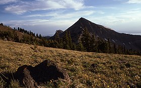
Mount Doane
| Mount Doane | |
|---|---|

1977
|
|
| Highest point | |
| Elevation | 10,551 ft (3,216 m) |
| Coordinates | 44°24′49″N 110°08′53″W / 44.41361°N 110.14806°WCoordinates: 44°24′49″N 110°08′53″W / 44.41361°N 110.14806°W |
| Geography | |
|
Yellowstone National Park, Park County, Wyoming
|
|
| Parent range | Absaroka Range |
| Topo map | Sylvan Lake |
Mount Doane el. 10,551 feet (3,216 m) is a mountain peak in the Absaroka Range in Yellowstone National Park. The peak is named for Lieutenant Gustavus Cheyney Doane, a U.S. Army cavalry officer who escorted the Washburn-Langford-Doane Expedition into Yellowstone in 1870. During that expedition, Doane and Nathaniel P. Langford ascended several peaks east of Yellowstone Lake. Henry D. Washburn, the leader of the expedition named a peak for Doane, but that peak's name was later changed to Mount Schurz. Mount Doane was officially named by the Hayden Geological Survey of 1871 to honor the first truly official report of an exploration of the Yellowstone region that Doane wrote after the Washburn expedition. Doane also participated in the 1st Hayden expedition in 1871.
Doane's account of his and Langford's ascent into the Absaroka Range (The Peak ascended is today's Colter Peak):
Seventeenth day -- September 7. -- In company with Mr. Langford, I climbed to the summit of a neighboring peak, the highest of the east range. We were four hours reaching the highest point, climbing for over a mile over shelly, feldspathic granite, after leaving our horses at the limit of pines.
Summit at noon, barometer, 20.35; thermometer, 65°; elevation, 10,327 feet.
Original Map of Yellowstone Lake showing the first Mount Doane
Mount Doane (left) and Mount Stevenson (right) 1871
...
Wikipedia

