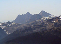
Mount Cayley
| Mount Cayley | |
|---|---|

The Mount Cayley volcanic complex in August 13, 2005. Summits left to right: Pyroclastic Peak, Mount Cayley
|
|
| Highest point | |
| Elevation | 2,377 m (7,799 ft) |
| Prominence | 674 m (2,211 ft) |
| Listing | List of volcanoes in Canada List of Cascade volcanoes |
| Coordinates | 50°07′13″N 123°17′26″W / 50.12028°N 123.29056°WCoordinates: 50°07′13″N 123°17′26″W / 50.12028°N 123.29056°W |
| Geography | |
| Location | Squamish River, British Columbia, Canada |
| Parent range | Pacific Ranges |
| Topo map | NTS 92J/03 |
| Geology | |
| Age of rock | |
| Mountain type | Stratovolcano (potentially active) |
| Volcanic arc/belt | Canadian Cascade Arc Garibaldi Volcanic Belt |
| Last eruption | |
| Climbing | |
| First ascent | 1928 E. Brooks, T. Fyles, W. Wheatley |
| Easiest route | rock/ice climb |
Mount Cayley is a potentially activestratovolcano in the Sea to Sky Country of southwestern British Columbia, Canada. Located 45 kilometres (28 mi) north of Squamish and 24 kilometres (15 mi) west of Whistler in the Pacific Ranges of the Coast Mountains, it rises 2,264 metres (7,428 ft) above the Squamish River to the west and 1,844 metres (6,050 ft) above the Cheakamus River to the east.
Mount Cayley consists of ridges, rounded lava domes, and sharp eroded rocky pinnacles with the highest reaching 2,377 metres (7,799 ft) in elevation. It lies at the southern end of a field of glacial ice called the Powder Mountain Icefield.
To the Squamish people, the local indigenous people of this territory, the mountain is called t'aḵ'taḵmu'yin tl'a in7in'a'xe7en. In their language it means "Landing Place of the Thunderbird". This name of the mountain refers to the legendary Thunderbird, a creature in North American indigenous peoples' history and culture. Like The Black Tusk further south, the rock was said to have been burnt black by the Thunderbird's lightning. This mountain, like others located in the area, is considered sacred because it plays an important part in their history.
...
Wikipedia
