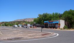
Mount Carmel Junction, Utah
| Mount Carmel Junction | |
|---|---|
| Unincorporated community | |
 |
|
| Location within the state of Utah | |
| Coordinates: 37°13′27″N 112°40′50″W / 37.22417°N 112.68056°WCoordinates: 37°13′27″N 112°40′50″W / 37.22417°N 112.68056°W | |
| Country | United States |
| State | Utah |
| County | Kane |
| Settled | 1871 |
| Elevation | 5,203 ft (1,586 m) |
| Time zone | Mountain (MST) (UTC-7) |
| • Summer (DST) | MDT (UTC-6) |
| ZIP codes | 84755 |
| Area code(s) | 435 |
| GNIS feature ID | 1437646 |
Mount Carmel Junction and Mount Carmel are unincorporated communities located 12 miles (19 km) east of Zion National Park and 17 miles (27 km) north of Kanab in Kane County, Utah, United States. They lie in close proximity to the Coral Pink Sand Dunes State Park.
Mount Carmel Junction sits at the junction of U.S. Route 89 and State Route 9 in southwestern Utah. Mount Carmel is one mile (1.6 km) north of the junction. Mount Carmel Junction is set in the high desert of the Colorado Plateau.
The Virgin Anasazi were the prehistoric settlers in the area. Among other areas, nearby Parunuweap (East Fork of the Virgin River) contains evidence to their presence. This group occupied the area until about the 13th century. The people were agriculturalists who maintained a diet of mostly maize.
Doctor Priddy Meeks settled the town of Winsor in 1864, at the site of present day Mount Carmel Junction, as part of Brigham Young's plan to settle all of Utah Territory. In 1865 more settlers were sent by the church. Nearby Orderville and Glendale (called Berryville at this time) were also being settled. Before long, Indians forced them to leave the area. It was not until 7 years later in 1871 that the settlers returned and this time settled down permanently. This time the town was settled in the name of Mount Carmel to honor the mountain in Palestine. In 1875 Elder Howard O. Spencer presided over Mount Carmel and Glendale. He reported that most homes were temporary, but permanent structures were underway. Doctor Meeks moved to Orderville in 1876 where he died at the age of 91. He left behind two wives and several children.
Only two families ever settled in Mount Carmel Junction, and one was Jack and Fern Morrison. Jack contemplated the idea that a road must be built connecting Zion Canyon to the east side of the park. Jack explored the area and came to the conclusion that the road must come down in the area now known as Mount Carmel Junction. There were old wagon trails that Jack used to navigate his way down to the valley. The hills were steep forcing Jack to attach a Cedar tree to the back of his Model-T-Ford. Jack was patient and in 1931 he was able to homestead the land now known as Mount Carmel Junction. The land was unkind. It was covered with gullies, quicksand and many layers of sand. The area was also prone to violent flash floods. Jack and Fern lost two children in the flash floods of the East Fork of the Virgin River that runs through the junction. The East Fork of the Virgin River is now known as Parunuweap. Jack died in 1961, from cancer after serving in the war and spending much of his life working in the coal mines. Fern, a strong willed and hard working woman continued to build. She lived to the age of 90, dying in 1998.
...
Wikipedia

