State Route 9 (Utah)
| State Route 9 | ||||
|---|---|---|---|---|
| Zion Park Scenic Byway | ||||
 |
||||
| Route information | ||||
| Defined by Utah Code §72-4-106 | ||||
| Maintained by UDOT | ||||
| Length: | 57.075 mi (91.853 km) | |||
| Existed: | 1920s as SR-15; renumbered in 1977 – present | |||
| Major junctions | ||||
| West end: |
|
|||
|
Zion National Park |
||||
| East end: |
|
|||
| Location | ||||
| Counties: | Washington, Kane | |||
| Highway system | ||||
|
||||
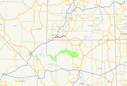
State Route 9 (SR-9) is a state highway in southern Utah, serving Zion National Park. It starts at the western terminus at exit 16 on I-15, passing through Zion National Park, and ending at the eastern junction with US-89. The entire length of the highway has been designated the Zion Park Scenic Byway. There is a fee to travel through Zion National Park, but the Zion-Mt. Carmel Highway is open to private vehicles year-round. A separate fee is required for vehicles 7'10" wide and/or 11'4" tall or larger. This fee pays for a park employee to stop traffic from the other side of the Zion - Mt. Carmel Tunnel to allow the larger vehicles to pass through. There is a smaller tunnel in Zion National Park that does not require an escort. Commercial vehicles are prohibited from using SR-9 and are directed to use SR-20 instead.
SR-9 begins at I-15, Exit 16, at Harrisburg Junction, just north of St. George. Immediately upon exiting I-15, SR-9 enters the Coral Canyon Development, which features an 18-hole golf course. Coral Canyon is split by the city boundaries of Hurricane and Washington Cities. Upon leaving this development, SR-9 passes through two ridges and begins its descent into the aptly named Purgatory Flats, home of the County Fairgrounds and a penitentiary. The 'flats' are a relatively level area between two sharply defined ridges. Quail Lake, which is in fact a reservoir, lies about a mile to the north of the road between these two ridges. Upon passing through the second ridge, SR-9 crosses the Virgin River & climbs a small plateau to the region of Hurricane known as Brentwood. The road descends from this plateau into downtown Hurricane, where SR-59 splits to the south and the Arizona Border. SR-9 then swings north towards the town of La Verkin, crossing an old bridge over the La Verkin River Ravine, before entering that town. In La Verkin, SR-17 takes off to the north, where it meets back up with I-15. After leaving La Verkin, SR-9 heads uphill and passes several mesas before eventually going through the small towns of Virgin, Rockville and Springdale.
...
Wikipedia

