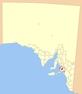
Mount Barker District Council
|
Mount Barker District Council South Australia |
|||||||||||||||
|---|---|---|---|---|---|---|---|---|---|---|---|---|---|---|---|
 |
|||||||||||||||
| Coordinates | 35°03′50″S 138°51′29″E / 35.0638888889°S 138.858055556°ECoordinates: 35°03′50″S 138°51′29″E / 35.0638888889°S 138.858055556°E | ||||||||||||||
| Population | 32,558 (2015 est) | ||||||||||||||
| • Density | 54.72/km2 (141.72/sq mi) | ||||||||||||||
| Established | 1853 | ||||||||||||||
| Area | 595 km2 (229.7 sq mi) | ||||||||||||||
| Mayor | Ann Ferguson | ||||||||||||||
| Council seat | Mount Barker | ||||||||||||||
| Region | Adelaide Hills | ||||||||||||||
| State electorate(s) | Kavel, Heysen | ||||||||||||||
| Federal Division(s) | Mayo | ||||||||||||||
 |
|||||||||||||||
| Website | Mount Barker District Council | ||||||||||||||
|
|||||||||||||||
The Mount Barker District Council is a local government area centred on the town of Mount Barker just outside the Adelaide metropolitan area in South Australia.
The council was first established in October 1853. It expanded to four times its original size on 21 March 1935 as part of a major series of council amalgamations, absorbing the District Council of Nairne and parts of the District Council of Echunga and the District Council of Macclesfield.
The current council as of June 2016 is:
Towns and localities in the Mount Barker District Council include:
...
Wikipedia
