Mount Baker-Snoqualmie National Forest
| Mount Baker-Snoqualmie National Forest | |
|---|---|
|
IUCN category VI (protected area with sustainable use of natural resources)
|
|

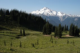
Glacier Peak from Image Lake
|
|
| Location | Washington, USA |
| Coordinates | 47°45′58″N 121°22′41″W / 47.766°N 121.378°WCoordinates: 47°45′58″N 121°22′41″W / 47.766°N 121.378°W |
| Area | 1,724,229 acres (6,977.71 km2) |
| Established | 1974; Mount Baker National Forest: January 21, 1924; Snoqualmie National Forest: July 1, 1908 |
| Governing body | U.S. Forest Service |
| Website | Mount Baker-Snoqualmie National Forest |
The Mount Baker-Snoqualmie National Forest in Washington is a National Forest extending more than 140 miles (230 km) along the western slopes of the Cascade Range from the Canada–US border to the northern boundary of Mount Rainier National Park. Administered by the United States Forest Service, the forest is headquartered in Everett.
The Mount Baker-Snoqualmie National Forest covers (in descending order of forestland area) portions of Snohomish, Whatcom, Skagit, King, Pierce, and Kittitas counties. It has a total area of 1,724,229 acres (6,978 km2). The forest consists of four ranger districts. The following are listed geographically from north to south: the Mount Baker District has two ranger stations located in Glacier and Sedro-Woolley; the Darrington Ranger District has two ranger stations located in Darrington and Verlot; the Skykomish Ranger District has one ranger station located in Skykomish; and the Snoqualmie Ranger District has two ranger stations located in North Bend and Enumclaw.
Together with the other central Puget Sound counties, 62% (3.63 million people) of the state's population lives within a 70-mile (110 km) drive of the forest. Another 1.5 million in the Vancouver metropolitan area are also within easy reach of the northern part of the forest. The large population factor, coupled with easy road access, makes the Mount Baker-Snoqualmie National Forest the second most visited national forest in the country.
...
Wikipedia

