Glacier, Washington
| Glacier, Washington | |
|---|---|
| CDP | |
 |
|
 Location of Glacier, Washington |
|
| Coordinates: 48°53′18″N 121°56′2″W / 48.88833°N 121.93389°W | |
| Country | United States |
| State | Washington |
| County | Whatcom |
| Area | |
| • Total | 3.0 sq mi (7.8 km2) |
| • Land | 3.0 sq mi (7.8 km2) |
| • Water | 0.0 sq mi (0.0 km2) |
| Elevation | 906 ft (276 m) |
| Population (2010) | |
| • Total | 211 |
| • Density | 29.9/sq mi (11.6/km2) |
| Time zone | Pacific (PST) (UTC-8) |
| • Summer (DST) | PDT (UTC-7) |
| ZIP code | 98244 |
| Area code | 360 |
| FIPS code | 53-26875 |
| GNIS feature ID | 1519971 |
| Highways |
|
Glacier is a census-designated place in Whatcom County, Washington, United States. The population was 211 at the 2010 census.
Based on per capita income, Glacier ranks 522nd (last) of 522 areas in the state of Washington to be ranked. Glacier is hoping to change this with the opening of the Glacier Chamber of Commerce.
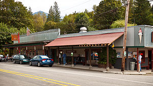
Glacier is the community closest to Mt. Baker (northernmost of the Cascade volcanoes), is within 10 air miles of Mt. Baker's summit and a 20-mile drive to the Mt. Baker Ski Area with awe-inspiring views of Mount Shuksan, one of the most photographed mountains in the world. It consists of a number of thriving businesses - including coffee shops, ski and snowboard shops, restaurants, a small grocery store, and a design company. The Glacier Public Service Center, staffed by both United States Forest Service and National Park Service personnel, has information about hiking and camping, less than a mile east.
Glacier was founded and named in 1909 by Jennie Vaughn.
Originally a site for gold mining and logging, commercial influence was probably the reason for both residential growth and interest by the Bellingham Bay and British Columbia Railroad. The area was made public after the creation of the Mount Baker Highway in 1923.
According to the United States Census Bureau, the CDP has a total area of 3.0 square miles (7.8 km²), all of it land.
As of the census of 2000, there were 90 people, 47 households, and 21 families residing in the CDP. The population density was 29.9 people per square mile (11.5/km²). There were 228 housing units at an average density of 75.8/sq mi (29.2/km²). The racial makeup of the CDP was 98.89% White, and 1.11% from two or more races. Hispanic or Latino of any race were 1.11% of the population.
...
Wikipedia
