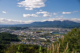
Mount Akagi
| Mount Akagi | |
|---|---|
| 赤城山 | |
 |
|
| Highest point | |
| Elevation | 1,828 m (5,997 ft) |
| Coordinates | 36°33′26″N 139°11′47″E / 36.55722°N 139.19639°ECoordinates: 36°33′26″N 139°11′47″E / 36.55722°N 139.19639°E |
| Naming | |
| Translation | Red Castle (Japanese) |
| Geography | |
| Geology | |
| Mountain type | Stratovolcano |
| Last eruption | Possibly 1251 |
Mount Akagi (赤城山 Akagi-yama?, English: Red Castle) is a mountain in Gunma Prefecture, Japan.
The broad, low dominantly andesitic stratovolcano rises above the northern end of the Kanto Plain. It contains an elliptical, 3 x 4 km summit caldera with post-caldera lava domes arranged along a NW-SE line. Lake Ono is located at the NE end of the caldera. An older stratovolcano was partially destroyed by edifice collapse, producing a debris-avalanche deposit along the south flank. A series of large plinian eruptions accompanied growth of a second stratovolcano during the . Construction of the central cone in the late-Pleistocene summit caldera began following the last of the plinian eruptions about 31,000 years ago. During historical time unusual activity was recorded on several occasions during the 9th century, but reported eruptions in 1251 and 1938 are considered uncertain.
Mount Akagi, along with Mount Myōgi and Mount Haruna, is one of the "Three Mountains of Jōmō" (上毛三山?), and the cold north winds down from it are called Akagi-oroshi (赤城おろし?) or Karakkaze (空っ風?).
...
Wikipedia

