Moundsville
| Moundsville, West Virginia | |
|---|---|
| City | |

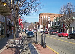
Jefferson Avenue in downtown Moundsville in 2006
|
|
 Location of Moundsville in Marshall County, West Virginia. |
|
| Coordinates: 39°55′17″N 80°44′22″W / 39.92139°N 80.73944°WCoordinates: 39°55′17″N 80°44′22″W / 39.92139°N 80.73944°W | |
| Country | United States |
| State | West Virginia |
| County | Marshall |
| Area | |
| • Total | 3.36 sq mi (8.70 km2) |
| • Land | 2.91 sq mi (7.54 km2) |
| • Water | 0.45 sq mi (1.17 km2) |
| Elevation | 696 ft (212 m) |
| Population (2010) | |
| • Total | 9,318 |
| • Estimate (2016) | 8,741 |
| • Density | 3,202.1/sq mi (1,236.3/km2) |
| Time zone | Eastern (EST) (UTC-5) |
| • Summer (DST) | EDT (UTC-4) |
| ZIP code | 26041 |
| Area code(s) | 304 |
| FIPS code | 54-56020 |
| GNIS feature ID | 1543607 |
| Website | http://www.cityofmoundsville.com/ |
Moundsville is a city in Marshall County, West Virginia, along the Ohio River. It is part of the Wheeling, WV-OH Metropolitan Statistical Area. The population was 9,318 at the 2010 census. It is the county seat of Marshall County. The city was named for the nearby ancient Grave Creek Mound, constructed 250 to 100 BC by indigenous people of the Adena culture.
Moundsville was settled in 1771 by English colonists Samuel and James Tomlinson. (Elizabethtown, as Tomlinson's community was called, was incorporated in 1830. Nearby, the town of Mound City was incorporated in 1832. The two towns combined in 1865.) Fostoria Glass Company (specializing in hand-blown glassworks) was headquartered in Moundsville from 1891 to 1986. The retired West Virginia State Penitentiary operated in Moundsville from 1867 to 1995.
Moundsville is located at 39°55′17″N 80°44′22″W / 39.92139°N 80.73944°W (39.921490, -80.739368).
According to the United States Census Bureau, the city has a total area of 3.36 square miles (8.70 km2), of which, 2.91 square miles (7.54 km2) is land and 0.45 square miles (1.17 km2) is water.
As of the census of 2010, there were 9,318 people, 4,016 households, and 2,445 families residing in the city. The population density was 3,202.1 inhabitants per square mile (1,236.3/km2). There were 4,458 housing units at an average density of 1,532.0 per square mile (591.5/km2). The racial makeup of the city was 97.5% White, 0.8% African American, 0.2% Native American, 0.4% Asian, 0.2% from other races, and 0.9% from two or more races. Hispanic or Latino of any race were 1.1% of the population.
...
Wikipedia
