Mound City, Missouri
| Mound City, Missouri | |
|---|---|
| City | |

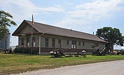
Mound City Museum, housed in a former C.B.& Q. Railroad depot
|
|
 Location of Mound City, Missouri |
|
| Coordinates: 40°8′5″N 95°13′51″W / 40.13472°N 95.23083°WCoordinates: 40°8′5″N 95°13′51″W / 40.13472°N 95.23083°W | |
| Country | United States |
| State | Missouri |
| County | Holt |
| Area | |
| • Total | 1.29 sq mi (3.34 km2) |
| • Land | 1.29 sq mi (3.34 km2) |
| • Water | 0 sq mi (0 km2) |
| Elevation | 889 ft (271 m) |
| Population (2010) | |
| • Total | 1,159 |
| • Estimate (2012) | 1,101 |
| • Density | 898.4/sq mi (346.9/km2) |
| Time zone | Central (CST) (UTC-6) |
| • Summer (DST) | CDT (UTC-5) |
| ZIP code | 64470 |
| Area code(s) | 660 |
| FIPS code | 29-50312 |
| GNIS feature ID | 0730155 |
Mound City is a city in Holt County, Missouri, United States, centered near the interchange of Interstate 29 and Missouri Route 118. The population was 1,159 at the 2010 census, slightly down from the 1,193 people counted during the previous census.
Mound City was originally called North Point, and under the latter name was platted in 1857. The present name is after mounds near the original town site. A post office called North Point was established in 1855, and the name was changed to Mound City in 1871.
Mound City is located in the northwest corner of Missouri at 40°8′5″N 95°13′51″W / 40.13472°N 95.23083°W (40.134594, -95.230778), at the southern end of the Loess Hills. It is named for the hills in the area. According to the United States Census Bureau, the city has a total area of 1.29 square miles (3.34 km2), all of it land.
Mound City is located in what was in the early 19th century considered to be unorganized Missouri Territory. In 1836, leaders of the Iowa, Sauk and Meskwaki peoples sold land that included what would become Mound City, as part of the 3,149 square miles (2,015,000 acres; 8,160 km2) of the Platte Purchase.
...
Wikipedia
