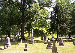
Mound Cemetery (Marietta, Ohio)
|
Mound Cemetery Mound
|
|

Mound Cemetery with Great Mound in background
|
|
| Location | 5th and Scammel Sts., Marietta, Ohio |
|---|---|
| Coordinates | 39°25′12″N 81°27′7″W / 39.42000°N 81.45194°WCoordinates: 39°25′12″N 81°27′7″W / 39.42000°N 81.45194°W |
| NRHP Reference # | 73001549 |
| Added to NRHP | February 23, 1973 |
Mound Cemetery in Marietta, Ohio is a historic cemetery developed around the base of a prehistoric Adena burial mound known as the Great Mound or Conus. The city founders preserved the Great Mound from destruction by establishing the city cemetery around it in 1801.
The city of Marietta was developed in 1788 by pioneers from Massachusetts, soon after the American Revolutionary War and organization of the Northwest Territory. Many of the founders were officers of the Revolutionary War who had received federal land grants for military services. Among high-ranking officers buried at the cemetery are generals Rufus Putnam and Benjamin Tupper, who were founders of the Ohio Company of Associates; as well as Commodore Abraham Whipple and Colonel William Stacy. The cemetery has the highest number of burials of American Revolutionary War officers in the country.
The conical Great Mound at Mound Cemetery is part of an Ohio Hopewell culture mound complex known as the Marietta Earthworks. Archaeologists estiumate that it was built between 100 BC and 500 AD. Early European American settlers gave the structures Latin names. The complex includes the Sacra Via (meaning "sacred way"), three walled enclosures, the Quadranaou, Capitolium (meaning "capital") and at least two other additional platform mounds, and the Conus burial mound and its accompanying ditch and embankment. The complex was surveyed and drawn in 1838 by Samuel R. Curtis (at the time a civil engineer for the state of Ohio). This survey was incorrectly attributed to Charles Whittlesey by E. G. Squier and E.H.Davis in their Ancient Monuments of the Mississippi Valley, published by the Smithsonian Institution in 1848. At the time the complex "included a large square enclosure surrounding four flat-topped pyramidal mounds, another smaller square, and a circular enclosure with a large burial mound at its center."
...
Wikipedia


