Motley, Minnesota
| Motley, Minnesota | |
|---|---|
| City | |
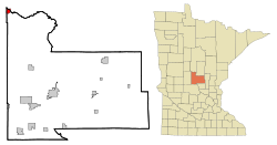
 Location of Motley within Morrison County, Minnesota |
|
| Coordinates: 46°20′6″N 94°38′45″W / 46.33500°N 94.64583°W | |
| Country | United States |
| State | Minnesota |
| Counties | Morrison, Cass |
| Area | |
| • Total | 1.38 sq mi (3.57 km2) |
| • Land | 1.33 sq mi (3.44 km2) |
| • Water | 0.05 sq mi (0.13 km2) |
| Elevation | 1,230 ft (375 m) |
| Population (2010) | |
| • Total | 671 |
| • Estimate (2012) | 663 |
| • Density | 504.5/sq mi (194.8/km2) |
| Time zone | Central (CST) (UTC-6) |
| • Summer (DST) | CDT (UTC-5) |
| ZIP code | 56466 |
| Area code(s) | 218 |
| FIPS code | 27-44422 |
| GNIS feature ID | 0648137 |
| Website | www.cityofmotley.com |
Motley is a city in Cass and Morrison counties in the U.S. state of Minnesota. The population was 671 at the 2010 census. The main part of Motley is located within Morrison County; only minor parts of the city extend into Cass County and Todd County.
The Cass County portion of Motley is part of the Brainerd Micropolitan Statistical Area.
Motley was laid out in 1874. A post office has been in operation at Motley since 1873.
According to the United States Census Bureau, the city has a total area of 1.38 square miles (3.57 km2), of which 1.33 square miles (3.44 km2) is land and 0.05 square miles (0.13 km2) is water.
U.S. Highway 10 and Minnesota State Highways 64 and 210 are three of the main routes in the city.
As of the census of 2010, there were 671 people, 305 households, and 167 families residing in the city. The population density was 504.5 inhabitants per square mile (194.8/km2). There were 338 housing units at an average density of 254.1 per square mile (98.1/km2). The racial makeup of the city was 94.5% White, 0.1% African American, 0.4% Native American, 1.6% from other races, and 3.3% from two or more races. Hispanic or Latino of any race were 4.3% of the population.
...
Wikipedia
