Mornington Shire Council
|
Mornington Shire Queensland |
|||||||||||||||
|---|---|---|---|---|---|---|---|---|---|---|---|---|---|---|---|

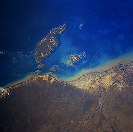
Mornington Island from space, September 1991
|
|||||||||||||||
| Population | 1,101 (2010) | ||||||||||||||
| • Density | 0.8937/km2 (2.3146/sq mi) | ||||||||||||||
| Established | 1978 | ||||||||||||||
| Area | 1,232 km2 (475.7 sq mi) | ||||||||||||||
| Mayor | Lou Rojhan | ||||||||||||||
| Council seat | Gununa | ||||||||||||||
| State electorate(s) | Mount Isa | ||||||||||||||
| Federal Division(s) | Kennedy | ||||||||||||||
 |
|||||||||||||||
| Website | Mornington Shire | ||||||||||||||
|
|||||||||||||||
Mornington Shire is a local government area in north-west Queensland, Australia. The Shire covers Mornington Island and neighbouring islands in the Wellesley Islands group in the Gulf of Carpentaria. The Shire Council employees are 93% local indigenous residents.
The administrative centre for the shire is the township of Gununa, on Mornington Island. In 2001 the Shire had a population of 934 of which 88.2% were Aboriginal.
The shire was formed in 1978 as a result of the Queensland Government's decision to take over control of the islands from the Uniting Church. The local community sought the assistance of the Federal Government to overturn the decision. The establishment of self governance for the community under a Local Government model was the result of the ensuing discussions.
Coordinates: 20°43′29″S 139°29′37″E / 20.72472°S 139.49361°E
...
Wikipedia
