Morissen
| Morissen | ||
|---|---|---|
| Former municipality of Switzerland | ||
 |
||
|
||
| Coordinates: 46°43′N 9°10′E / 46.717°N 9.167°ECoordinates: 46°43′N 9°10′E / 46.717°N 9.167°E | ||
| Country | Switzerland | |
| Canton | Graubünden | |
| District | Surselva | |
| Area | ||
| • Total | 5.7 km2 (2.2 sq mi) | |
| Elevation | 1,337 m (4,386 ft) | |
| Population (Dec 2011) | ||
| • Total | 223 | |
| • Density | 39/km2 (100/sq mi) | |
| Postal code | 7143 | |
| SFOS number | 3596 | |
| Surrounded by | Cumbel, Luven, Surcuolm, Vella | |
| Website | SFSO statistics |
|
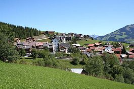
Morissen (Romansh: Murissen) is a former municipality in the district of Surselva in the Swiss canton of Graubünden. The municipalities of Cumbel, Degen, Lumbrein, Morissen, Suraua, Vignogn, Vella, and Vrin merged on 1 January 2013 into the new municipality of Lumnezia.
Morissen is first mentioned in 1210 as Mureizens.
The municipal coat of arms is Gules three Escallops Or. The scallops on the coat of arms represent St. James the Elder who is the patron saint of the village church.
Morissen had an area, as of 2006[update], of 5.7 km2 (2.2 sq mi). Of this area, 86.8% is used for agricultural purposes, while 6.2% is forested. Of the rest of the land, 3.7% is settled (buildings or roads) and the remainder (3.3%) is non-productive (rivers, glaciers or mountains).
The former municipality is located in the Lugnez sub-district of the Surselva district on the southern foot of the Piz Mundaun and above the Lugnezerstrasse.
Morissen has a population (as of 2011) of 223. As of 2008[update], 2.5% of the population was made up of foreign nationals. Over the last 10 years the population has decreased at a rate of -10.3%. Most of the population (as of 2000[update]) speaks Romansh(91.5%), with German being second most common ( 6.6%) and English being third ( 0.9%).
...
Wikipedia


