Morgan County, Alabama
| Morgan County, Alabama | |
|---|---|

The Morgan County Courthouse in Decatur
|
|
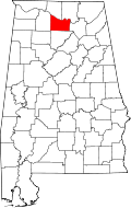
 Location in the U.S. state of Alabama |
|
 Alabama's location in the U.S. |
|
| Founded | February 6, 1818 |
| Named for | Daniel Morgan |
| Seat | Decatur |
| Largest city | Decatur |
| Area | |
| • Total | 599 sq mi (1,551 km2) |
| • Land | 579 sq mi (1,500 km2) |
| • Water | 20 sq mi (52 km2), 3.3% |
| Population (est.) | |
| • (2015) | 119,565 |
| • Density | 207/sq mi (80/km²) |
| Congressional district | 5th |
| Time zone | Central: UTC-6/-5 |
| Website | www |
|
Footnotes:
|
|
Footnotes:
Morgan County is a county in the north central part of the U.S. state of Alabama. As of the 2010 census the population was 119,490. The county seat is Decatur. The county was created by the Alabama Territorial legislature on February 6, 1818 from land acquired from the Cherokee Indians in the Treaty of Turkeytown, and was originally called Cotaco County. On June 14, 1821 it was renamed in honor of American Revolutionary War General Daniel Morgan of Virginia. It is a prohibition or dry county, though the city of Decatur is wet.
Morgan County is included in the Decatur, AL Metropolitan Statistical Area, which is also included in the Huntsville-Decatur-Albertville, AL Combined Statistical Area. It is a part of the North, Northwest, and North-Central regions of Alabama.
According to the U.S. Census Bureau, the county has a total area of 599 square miles (1,550 km2), of which 579 square miles (1,500 km2) is land and 20 square miles (52 km2) (3.3%) is water.
As of the census of 2000, there were 111,064 people, 43,602 households, and 31,437 families residing in the county. The population density was 191 people per square mile (74/km2). There were 47,388 housing units at an average density of 81 per square mile (31/km2). The racial makeup of the county was 85.07% White, 11.24% Black or African American, 0.67% Native American, 0.45% Asian, 0.07% Pacific Islander, 1.25% from other races, and 1.25% from two or more races. 3.28% of the population were Hispanic or Latino of any race.
...
Wikipedia
