Moreton Basin
| Clarence Moreton Basin | |
|---|---|

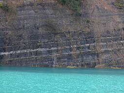
Walloon Coal Measures exposed in quarry at Bexhill
|
|
| Location in Australia | |
| Location | Northern Rivers region in New South Wales and South East region of Queensland |
| Coordinates | 30°00′N 152°30′E / 30°N 152.5°ECoordinates: 30°00′N 152°30′E / 30°N 152.5°E |
| Range | Tweed, Border, Lamington, McPherson |
| Geology | Sedimentary basin |
| Age | Late Triassic to late Jurassic |
| Website | Geoscience Australia |
The Clarence Moreton Basin is a Mesozoic sedimentary basin on the easternmost part of the Australian continent. It is located in the far north east of the state of New South Wales around Lismore and Grafton and in the south east corner of Queensland. It formed by oblique extension of the underlying Paleozoic New England Orogen basement. It consists of continental deposits, starting with a small amount of Triassic coal beds, and then mostly Jurassic and Cretaceous sedimentary rocks. The basin covers 16,000 square kilometres (6,200 sq mi). The basin was named when the Clarence Basin (named after the Clarence River) and Moreton Basin in Queensland were proved to be one structure.
The oldest rocks in the Clarence Moreton Basin of New South Wales are the Chillingham Volcanics. These are from some time in the Triassic period, and outcrop in a band north and south of Chillingham. They consist of conglomerate at the base, Rhyolite, lithic rhyolitic tuff, and shale. The Nymboida Coal measures extend from Nymboida to Kangaroo Creek. They consist of lithic sandstones (wackes, minor arenites), siltstone, polymictic conglomerate, coal, rhyolitic tuff, and basalt. The total thickness is over 1,000 metres (3,300 ft). The outcrop is 90 square kilometres (35 sq mi), and it forms a north west trending band 29 kilometres (18 mi) long on the southwest tip of the basin. Fossils reveal a date of middle Triassic. A lower part is called Cloughers Creek Formation. The Basin Creek Formation includes the coal mined at Nymboida. The Bardool Conglomerate forming a 180 m thick layer, is also a unit in the coal measures. The conglomerate includes a 15-metre (49 ft) thick layer of basalt exposed at Copes Creek.
...
Wikipedia

