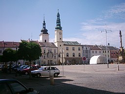
Moravská Třebová
| Moravská Třebová | |||
| Town | |||
|
Square
|
|||
|
|||
| Country | Czech Republic | ||
|---|---|---|---|
| Region | Pardubice | ||
| District | Svitavy | ||
| Commune | Moravská Třebová | ||
| Elevation | 360 m (1,181 ft) | ||
| Coordinates | 49°45′N 16°40′E / 49.750°N 16.667°ECoordinates: 49°45′N 16°40′E / 49.750°N 16.667°E | ||
| Area | 42.205 km2 (16.295 sq mi) | ||
| Population | 11,414 | ||
| Density | 270/km2 (699/sq mi) | ||
| First mentioned | 1270 | ||
| Mayor | Miloš Izák | ||
| Timezone | CET (UTC+1) | ||
| - summer (DST) | CEST (UTC+2) | ||
| Postal code | 571 01 | ||
| Statistics: statnisprava.cz | |||
| Website: www.mtrebova-city.cz | |||
Moravská Třebová (Czech pronunciation: [ˈmorafskaː ˈtr̝̊ɛbovaː]; German: Mährisch Trübau) is a town in the Svitavy District and lies in the Pardubice Region, Czech Republic. It has around 11,300 inhabitants.
Moravská Třebová is located on the Třebůvka River.
It was the largest German linguistic enclave within Bohemia and Moravia. Some locations were just some kilometers apart from the other German-speaking areas. Until the expulsion of the Germans in 1945/46 according to the Beneš decrees, it was exclusively inhabited by German-speaking population. Between 1850 and 1960 Moravská Třebová has been a district town.
Part of the town of Moravská Třebová are the incorporated villages of Boršov, Sušice and Udánky.
Moravská Třebová was founded around 1257 by Boreš of Rýzmburk as typical colonization town. The biggest boom for Moravská Třebová during the rule of the Lords of Boskovic and Ladislav Velen of Žerotín (1486-1622), when the city was the center of humanistic scholarship and earned the nickname Moravian Athens.
Until 1918 the town was part of the Austrian monarchy (Austria side after the compromise of 1867), head of the district with the same name, one of the 34 Bezirkshauptmannschaften in Moravia.
...
Wikipedia


