Moovattupuzha
|
Muvattupuzha മൂവാറ്റുപുഴ Moovattupuzha |
|
|---|---|
| Big Town | |

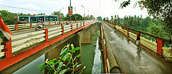
Muvattupuzha Old and New Bridges
|
|
| Location in Kerala, India | |
| Coordinates: 9°58′01″N 76°34′59″E / 9.9670°N 76.5830°ECoordinates: 9°58′01″N 76°34′59″E / 9.9670°N 76.5830°E | |
| Country |
|
| State | Kerala |
| District | Ernakulam |
| Government | |
| • Type | Municipality |
| • Municipal Chairperson | Usha Sasidharan |
| Area | |
| • Total | 13.18 km2 (5.09 sq mi) |
| Elevation | 15 m (49 ft) |
| Population (2011) | |
| • Total | 30,397 |
| • Density | 2,306.3/km2 (5,973/sq mi) |
| Languages | |
| • Official | Malayalam, English |
| Time zone | IST (UTC+5:30) |
| PIN | 686661 |
| Telephone code | 0485 |
| Vehicle registration | KL-17 |
| Nearest city | Ernakulam, Kottayam |
| Sex ratio | 1023 ♂/♀ |
| Lok Sabha constituency | Idukki |
| Climate | Tropical monsoon (Köppen) |
| Avg. summer temperature | 32.5 °C (90.5 °F) |
| Avg. winter temperature | 20 °C (68 °F) |
| The town where three rivers merge to form Muvattupuzha river. | |
Muvattupuzha is a merger place of three rivers – namely Thodupuzhayar (Thodupuzha river), Kaliyar (Kali river) and Kothayar (Kothamangalam river) – to form Muvattupuzhayar, and hence this Thriveni Sangamam or confluence of three rivers is called Muvattupuzha.
Muvattupuzha is a municipality in the eastern side of Ernakulam district in the Indian state of Kerala. The town is bordered by Kottayam district on southern side and Idukki district on eastern side approximately 20 km from the town. Muvattupuzha lies on the intersection between M C Road and National Highway 49, about 42 km from district capital Ernakulam.It is the second biggest commercial centre of the district and one of the biggest in the eastern part of the state.
The town is named after the Muvattupuzha river which flows through it. The name is made up of three Malayalam words: Moonnu, which stands for three; aaru, small river; and puzha, which also means river. Aaru is a word that is usually used for rivers in the southern half of Kerala, while the term puzha is used in the northern parts. The three rivers in this case are the Kothamangalam river or Kothayaar, Kaliyar and Thodupuzhayar, which merge to form a single river called Muvattupuzhayar. This place is called Thriveni Sangamam in Malayalam which means the point of confluence of three rivers.
In English both spellings viz. Muvattupuzha and Moovattupuzha are interchangeably used. Etymologically Moovattupuzha, is the correct spelling how ever commoners widely use the spelling Muvattupuzha and is better accepted.
Muvattupuzha was part of the Vadakkumkoor Kingdom until it was captured by the Travancore Kingdom. Old documents show that parts of the lands of Muvattupuzha belonged to Edappally Swaroopam, but were later transferred to Manas' (Brahmin Families).
...
Wikipedia


