Moose Lake, Minnesota
| Moose Lake, Minnesota | |
|---|---|
| City | |

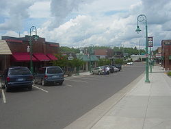
Downtown Moose Lake
|
|
 Location of the city of Moose Lake within Carlton County, Minnesota |
|
| Coordinates: 46°27′5″N 92°45′48″W / 46.45139°N 92.76333°W | |
| Country | United States |
| State | Minnesota |
| County | Carlton |
| Area | |
| • Total | 3.66 sq mi (9.48 km2) |
| • Land | 3.27 sq mi (8.47 km2) |
| • Water | 0.39 sq mi (1.01 km2) |
| Elevation | 1,060 ft (323 m) |
| Population (2010) | |
| • Total | 2,751 |
| • Estimate (2012) | 2,787 |
| • Density | 841.3/sq mi (324.8/km2) |
| Time zone | Central (CST) (UTC-6) |
| • Summer (DST) | CDT (UTC-5) |
| ZIP code | 55767 |
| Area code(s) | 218 |
| FIPS code | 27-43954 |
| GNIS feature ID | 0648082 |
| Website | www.cityofmooselake.com |
Moose Lake is a city in Carlton County, Minnesota, United States. The population was 2,751 at the 2010 census.
Interstate 35; Minnesota State Highways 27 and 73; and County 61 are four of the main routes in Moose Lake.
Moose Lake State Park is nearby.
According to the United States Census Bureau, the city has a total area of 3.66 square miles (9.48 km2), of which, 3.27 square miles (8.47 km2) is land and 0.39 square miles (1.01 km2) is water.
The boundary line between Carlton and Pine counties is nearby.
Moose Lake is located 25 miles southwest of Cloquet. Moose Lake is located 43 miles southwest of Duluth; and 112 miles north of Minneapolis–Saint Paul.
As with the rest of Minnesota, Moose Lake has a humid continental climate. Similar to the rest of the northern half of the state it has the warm-summer variety with relatively cool nights year-round. Winter temperatures are very cold but dry compared to summer.
Moose Lake was one of the communities affected by the massive 1918 Cloquet Fire. The Minneapolis, St. Paul and Sault Ste. Marie Depot is a museum that tells the story of that fire. The Minnesota Home Guard provided assistance to the area following the fire.
...
Wikipedia
