Moore River (Western Australia)
| Moore River | |
|---|---|

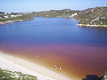
The Moore River estuary at Guilderton
|
|
| Country | Australia |
| Basin features | |
| Main source |
Perenjori 162 m (531 ft) |
| River mouth |
Indian Ocean sea level |
| Basin size | 13,800 km2 (5,328 sq mi) |
| Physical characteristics | |
| Length | 193 km (120 mi) |
| Discharge |
|
Moore River is a river in the Wheatbelt region of Western Australia.
The headwaters of the Moore River lie in the Perenjori, Carnamah and Dalwallinu Shires. The river then drains southwards through Moora, flows westerly before joining with the Moore River East near Mogumber, then flows in a westerly direction over the Edengerie Cascade, through the northern edge of the Moore River Nature Reserve, then through the Gingin Scarp, discharging into the Indian Ocean at Guilderton.
The river includes a catchment that extends from just south of Three Springs to Guilderton. The catchment has a total area of 13,800 square kilometres (5,328 sq mi) and is 80% cleared for agriculture. The catchment area is used for broadacre farming but with increasing diversification in horticulture and tree plantations. The river mouth at Guilderton typically closes during the summer months due to insufficient water flow, creating a sandbar.
The river has nine subcatchment areas and has a number of tributaries and lakes along the length of the river. The salinity levels in the river catchment vary from brackish to saline with the exception of Gingin Brook which remains fresh throughout the year.
The Aboriginal people referred to the lower part of the river as Garban. It was renamed River Moore in May 1836 by Corporal Patrick Heffron of the 63rd Regiment of Foot, after his expedition leader George Fletcher Moore, Advocate-General. The exploratory party comprised Moore, Heffron and an Aboriginal man named Weenat. Heffron was notable for his participation in the Battle of Pinjarra in 1834.
...
Wikipedia
