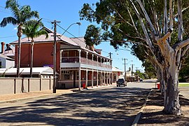
Moora, Western Australia
|
Moora Western Australia |
|||||||
|---|---|---|---|---|---|---|---|

Moora, Western Australia.
|
|||||||
| Population | 1,822 (2011 census) | ||||||
| Postcode(s) | 6510 | ||||||
| Elevation | 203 m (666 ft) | ||||||
| Location |
|
||||||
| LGA(s) | Shire of Moora | ||||||
| State electorate(s) | Moore | ||||||
| Federal Division(s) | Durack | ||||||
|
|||||||
Coordinates: 30°38′17″S 116°00′36″E / 30.638°S 116.01°E
Moora is a townsite located 177 km north of Perth in the Wheatbelt region of Western Australia. Moora was one of the original stations on the Midland railway line to Walkaway, and the townsite was gazetted in 1895. At the 2006 census, Moora had a population of 1,822.
The town is the most substantial wheat belt town between Geraldton and Perth. The town provides facilities and services such as commercial banks, schools, commerce and retail sectors, community recreational facilities; plus a Pharmacy, Dentist, Doctors and District Hospital.
The surrounding areas produce wheat and other cereal crops. The town is a receival site for Cooperative Bulk Handling.
The town was left underwater in 1932 when heavy rainfall inundated the town causing severe flooding. The town was left isolated as both rail lines and roads had portions washed away. Over half the town was submerged to a depth of 3 feet (90 cm) and once the waters receded was left under a thick coating of mud. Crops and stock in the surrounding area were also lost.
In March 1999, the town suffered a major flood when ex-Tropical Cyclone Elaine caused the Moore River to break its banks with the evacuation of 1000 people. Just as the community was recovering, another major rainfall event on the already saturated land in May the same year caused yet another flood in the town.
...
Wikipedia
