Moore County, North Carolina
| Moore County, North Carolina | |
|---|---|

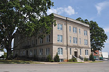
Moore County Courthouse, in Carthage
|
|
 Location in the U.S. state of North Carolina |
|
 North Carolina's location in the U.S. |
|
| Founded | 1784 |
| Named for | Alfred Moore |
| Seat | Carthage |
| Largest village | Pinehurst |
| Area | |
| • Total | 706 sq mi (1,829 km2) |
| • Land | 698 sq mi (1,808 km2) |
| • Water | 8.0 sq mi (21 km2), 1.1% |
| Population (est.) | |
| • (2015) | 95,776 |
| • Density | 126/sq mi (49/km²) |
| Congressional district | 8th |
| Time zone | Eastern: UTC-5/-4 |
| Website | www |
Moore County is a county located in the U.S. state of North Carolina. As of the 2010 census, the population was 88,247. Its county seat is Carthage and its largest town is Pinehurst.
Moore County comprises the Aberdeen- Pinehurst-Southern Pines, North Carolina Micropolitan Statistical Area and is sometimes included in the Research Triangle and Greater Raleigh-Durham CSA. It lies at the northern edge of the area known as the Sandhills region.
The county was formed in 1785 from Cumberland County. It was named after Alfred Moore, an officer in the American Revolutionary War and associate justice of the Supreme Court of the United States.
In 1907 parts of Moore County and Chatham County were combined to form Lee County.
Moore County has many golf resorts in the Southern Pines/Pinehurst area, and hosted the 1996 and 2001 Women's U.S. Opens as well as the 1999 and 2005 Men's U.S. Opens. The Women's Open returned to Southern Pines in 2007. In 2014, they consecutively hosted both the Women's and Men's Opens in the same year, a first in U.S. Open history.
...
Wikipedia
