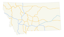
Montana Highway System

Construction sign for I-90 in Montana during the mid-20th century
|
|||
| Overview | |||
|---|---|---|---|
| Transit type | Rapid transit, commuter rail, buses, private automobile, taxicab, bicycle, pedestrian, highways | ||
| Website | http://www.mdt.mt.gov/ | ||
| Operation | |||
| Operator(s) | Montana Department of Transportation | ||
|
|||
Transportation in Montana comprises many different forms of travel. Montana shares a long border with Canada, hence international crossings are prevalent in the northern section of the state; there are 13 road crossings and one rail crossing.
As the fourth-largest state in the United States, journeying from one side to the other takes a long time. The state has an extensive network of roads, including state highways, Interstate highways and U.S. routes. Rail connections are also well-established and were an important method of transportation in Montana since the 1880s. Within individual cities, public transportation includes rapid transit and high-frequency bus services.
For travel further afield, 16 airports are operational within Montana. Bozeman Yellowstone International Airport in Gallatin County is the busiest airport and there are another seven major airports and eight minor ones providing commercial services.
Montana has approximately 70,000 miles (112,654 km) of highways which start in, pass through or are entirely inside the state.
1,198.8 miles (1929.2 km) of the Interstate Highway System, which serve as a thoroughfare for long-distance road journeys, is contained within Montana, and all of these are maintained by the Montana Department of Transportation (MDT). All the interstates originate at or pass through the Helena area, the state capital.
...
Wikipedia

