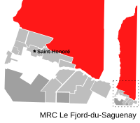
Mont-Valin, Quebec
| Mont-Valin | |
|---|---|
| Unorganized territory | |
 |
|
| Location in Saguenay–Lac-Saint-Jean Quebec. | |
| Coordinates: 48°37′N 70°48′W / 48.617°N 70.800°WCoordinates: 48°37′N 70°48′W / 48.617°N 70.800°W | |
| Country |
|
| Province |
|
| Region | Saguenay–Lac-Saint-Jean |
| RCM | Le Fjord-du-Saguenay |
| Constituted | February 18, 2002 |
| Government | |
| • Federal riding | Chicoutimi—Le Fjord |
| • Prov. riding | Dubuc |
| Area | |
| • Total | 38,032.30 km2 (14,684.35 sq mi) |
| • Land | 35,080.51 km2 (13,544.66 sq mi) |
| Population (2011) | |
| • Total | 5 |
| • Density | 0.0/km2 (0/sq mi) |
| • Pop (2006–11) |
|
| • Dwellings | 4 |
| Time zone | EST (UTC-5) |
| • Summer (DST) | EDT (UTC-4) |
Mont-Valin is an unorganized territory in the Canadian province of Quebec. It makes up over 87% of Le Fjord-du-Saguenay Regional County Municipality and is the largest subdivision of the Saguenay–Lac-Saint-Jean region. The territory, named after Mount Valin, had a population of 5 as of the Canada 2011 Census, and covered a land area of 35,080.51 km2.
The territory has one settlement: the hamlet of Chutes-des-Passes, located 160 kilometres (99 mi) north of Chicoutimi (49°50′23″N 71°09′55″W / 49.83972°N 71.16528°W). It was founded in 1941, when Alcan built a dam on the Peribonka River. When operation of the dam was automated in 1974, the community was almost entirely abandoned.
Population trend:
Private dwellings occupied by usual residents: 3 (total dwellings: 4)
...
Wikipedia

