Monsaraz
| Monsaraz | ||
|---|---|---|
| Parish | ||

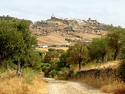
A view from the hilltop of Monte Xarez, showing the Castle of Monsaraz
|
||
|
||
| Coordinates: 38°26′38″N 7°22′52″W / 38.444°N 7.381°WCoordinates: 38°26′38″N 7°22′52″W / 38.444°N 7.381°W | ||
| Country | Portugal | |
| Region | Alentejo | |
| Subregion | Alentejo Central | |
| Intermunic. comm. | Alentejo Central | |
| District | Évora | |
| Municipality | Reguengos de Monsaraz | |
| Area | ||
| • Total | 88.29 km2 (34.09 sq mi) | |
| Elevation | 195 m (640 ft) | |
| Population (2011) | ||
| • Total | 782 | |
| • Density | 8.9/km2 (23/sq mi) | |
| Postal code | 7200 | |
| Area code | 266 | |
| Patron | Santa Maria da Lagoa | |
| Website | http://www.monsaraz.pt/ | |
Monsaraz is a civil parish (freguesia) of the municipality of the Reguengos de Monsaraz, on the right margin of the Guadiana River in Portuguese Alentejo region, near its border with Spain. The population in 2011 was 782, in an area of 88.29 km².
Due to its geographic position, the hilltop of Monsaraz always occupied an important place in the history of the municipality, having been occupied by different peoples since the pre-historical record. It is one of the oldest Portuguese settlements of the southern Portugal, occupied since pre-history, whose examples of permanent habitation include hundreds of megalithic monuments. These include the neolithic remains of: Megalithic Monuments of Herdade de Xerez, Olival da Pega Dolmen (Anta), Bulhoa Menhir, Rocha dos Namorados Menhir and Outeiro Menhir. The hill, on which the main settlement is located, was a pre-historic fortification, or castro, that was the basis of pre-Roman occupation and funerary temples, carved from the local rock.
Monsaraz was reorganized during the Roman occupation, but later successively occupied by the Visigoths, Arabs, Mozarabs, Jews, and, after the Reconquista, Christians loyal to Afonso Henriques. In the 8th century, Monsaraz fell under the dominion of Arab forces who occupied the Iberian Peninsula, becoming known as Saris or Sharish, and following the control of the Taifa of Badajoz (one of the more prominent Arab centres at the time). The name Monsaraz originates from the word Xarez or Xerez, the Iberian transliteration of the Arabic Saris or Sharish, for the Gum Rockrose (Cistus ladanifer L.), a plant that still today prospers in poor, dry, acidic slate-based soil that surrounds Monsaraz. The Iberian words Xarez/Xerez latter evolved to the Portuguese Xaraz and to the Spanish {Castilian) Jerez (the Spanish name for the sherry wine). The settlement that became Monsaraz, originated from the Monte Xaraz, a fortified hill surrounded by Gum Rockroses. It is natural position, the highest hill in the area and proximity to the deep Guadiana valley, made it a location of strategic importance.
...
Wikipedia


