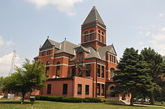
Monona County, Iowa
| Monona County, Iowa | |
|---|---|

|
|
 Location in the U.S. state of Iowa |
|
 Iowa's location in the U.S. |
|
| Founded | 1851 |
| Seat | Onawa |
| Largest city | Onawa |
| Area | |
| • Total | 699 sq mi (1,810 km2) |
| • Land | 694 sq mi (1,797 km2) |
| • Water | 4.9 sq mi (13 km2), 0.7% |
| Population (est.) | |
| • (2015) | 8,979 |
| • Density | 13/sq mi (5/km²) |
| Congressional district | 4th |
| Time zone | Central: UTC-6/-5 |
Monona County is a county located in the U.S. state of Iowa. As of the 2010 census, the population was 9,243. The county seat is Onawa.
Monona County was formed in 1851. It was perhaps named for the Indian word meaning "beautiful valley."
When Ashton (originally called Bloomfield ) was named the county seat in the fall of 1854, a log house served as the first courthouse. Ashton remained the county seat for only four years. On April 5, 1858, Onawa was voted the permanent seat of the county.
The first Monona County Courthouse was completed in 1858.
According to the U.S. Census Bureau, the county has a total area of 699 square miles (1,810 km2), of which 694 square miles (1,800 km2) is land and 4.9 square miles (13 km2) (0.7%) is water.
The 2010 census recorded a population of 9,243 in the county, with a population density of 13.3354/sq mi (5.14881/km2). There were 4,697 housing units, of which 4,050 were occupied.
As of the census of 2000, there were 10,020 people, 4,211 households, and 2,737 families residing in the county. The population density was 14 people per square mile (6/km²). There were 4,660 housing units at an average density of 7 per square mile (3/km²). The racial makeup of the county was 98.34% White, 0.08% Black or African American, 0.76% Native American, 0.12% Asian, 0.04% Pacific Islander, 0.08% from other races, and 0.58% from two or more races. 0.70% of the population were Hispanic or Latino of any race.
...
Wikipedia
