Molongolo River
| Molonglo (Yeal-am-bid-gie) | |
| River | |
|
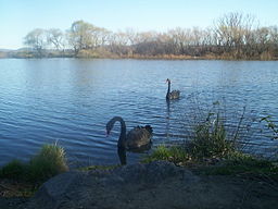
Black swans on Molonglo River
|
|
| Name origin: Aboriginal: "like the sound of thunder" | |
| Country | Australia |
|---|---|
| States | New South Wales, Australian Capital Territory |
| Regions | South Eastern Highlands (IBRA), Monaro, Capital Country |
| Municipalities | Palerang, Queanbeyan |
| Part of | Murrumbidgee River, Murray-Darling basin |
| Tributaries | |
| - left | Queanbeyan River, Jerrabomberra Creek |
| - right | Sullivans Creek |
| City | Queanbeyan |
| Landmarks | Molonglo Plain, Molonglo Gorge |
| Source | Tinderry Range, Great Dividing Range |
| - location | near Captains Flat |
| - elevation | 1,130 m (3,707 ft) |
| - coordinates | 35°40′5″S 149°29′50″E / 35.66806°S 149.49722°E |
| Mouth | confluence with the Murrumbidgee River |
| - location | near Uriarra Crossing |
| - elevation | 440 m (1,444 ft) |
| - coordinates | 35°14′30″S 148°58′4″E / 35.24167°S 148.96778°ECoordinates: 35°14′30″S 148°58′4″E / 35.24167°S 148.96778°E |
| Length | 115 km (71 mi) |
| Basin | 198,900 km2 (76,796 sq mi) |
| Nature reserves | Molonglo Gorge Recreation Reserve, Jerrabomberra Wetlands, Lower Molonglo Nature Reserve |
| Reservoir | Lake Burley Griffin |
| Dam | Scrivener Dam |
The Molonglo River, a perennial river that is part of the Murrumbidgee catchment within the Murray–Darling basin, is located in the Monaro and Capital Country regions of New South Wales and the Australian Capital Territory, in Australia.
The river rises on the western side of the Great Dividing Range, in Tallaganda State Forest at 1,130 metres (3,710 ft) and flows generally from south to north before turning northwest, through Carwoola and the outskirts of Queanbeyan, where it has confluence with its major tributary, the Queanbeyan River, and then continues through Canberra, where it has been dammed by the Scrivener Dam to form Lake Burley Griffin. The river then flows to its mouth with the Murrumbidgee River, near Uriarra Crossing. Over its 115 kilometres (71 mi) course the Molonglo River alternates between long broad floodplains and narrow rocky gorges several times. One of these floodplains is called the Molonglo Plain.
From source to mouth, the river is traversed by the Captains Flat Road at Captains Flat, Briars-Sharrow Road in Carwoola, the Kings Highway between Queanbeyan and Bungendore, the Yass Road, north of Queanbeyan, the Monaro Highway at Pialligo, the Commonwealth and Kings Avenues as Lake Burley Griffin between Parkes and Acton, Lady Denman Drive at Scrivener Dam, and the Tuggeranong Parkway north of the Glenloch Interchange.
...
Wikipedia


