Mole Valley District Council
| Mole Valley District | |
|---|---|
| Non-metropolitan district | |

Leatherhead High Street
|
|
| Motto: Ministrando vigilans (Latin: Vigilant in our serving) |
|
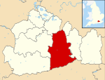
 Mole Valley shown within Surrey |
|
| Sovereign state | United Kingdom |
| Constituent country | England |
| Region | South East England |
| Non-metropolitan county | Surrey |
| Status | Non-metropolitan district |
| Admin HQ | Dorking |
| Incorporated | 1 April 1974 |
| Government | |
| • Type | Non-metropolitan district council |
| • Body | Mole Valley District Council |
| • Leadership | Alternative - Sec.31 (Conservative) |
| • MPs |
Paul Beresford Chris Grayling |
| Area | |
| • Total | 99.7 sq mi (258.3 km2) |
| Area rank |
153rd (of 326) Highest point : Leith Hill |
| Population (mid-2015 est.) | |
| • Total | 86,100 |
| • Rank | 277th (of 326) |
| • Density | 860/sq mi (330/km2) |
| • Ethnicity | 97.4% White |
| Time zone | GMT (UTC0) |
| • Summer (DST) | BST (UTC+1) |
| ONS code | 43UE (ONS) E07000210 (GSS) |
| OS grid reference | TQ0496458567 |
| Website | www |
153rd (of 326)
Mole Valley is a local government district in Surrey, England. Its council is based in Dorking.
The two towns in the district are Dorking and Leatherhead. The largest villages are Ashtead, Fetcham and Great Bookham, in the northern third of the district. The rest of the district includes some of the Surrey Hills AONB, the middle of the district is dominated by the North Downs, including Polesden Lacey, Box Hill, Denbies Wine Estate (the largest vineyard in the country ) and parts of the Pilgrims' Way, the southern third includes Leith Hill and the Greensand Ridge. There are stations on the London–Worthing and Reading–Gatwick Airport railways, and in the northern third, a commuter stopping service from London–Guildford. Additionally the A24 road and the M25 motorway are the main thoroughfares.
Mole Valley District Council is elected by thirds: one-third of councillors are elected at each election, each serving four year terms; three years out of four having elections.
...
Wikipedia
