Mogadore, Ohio
| Mogadore, Ohio | |
|---|---|
| Village | |

|
|
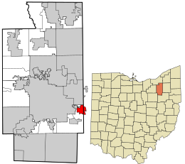
 Location in Summit County and the state of Ohio. |
|
| Coordinates: 41°3′8″N 81°23′50″W / 41.05222°N 81.39722°WCoordinates: 41°3′8″N 81°23′50″W / 41.05222°N 81.39722°W | |
| Country | United States |
| State | Ohio |
| Counties | Summit, Portage |
| Government | |
| • Mayor | Mike Rick |
| Area | |
| • Total | 2.11 sq mi (5.46 km2) |
| • Land | 2.09 sq mi (5.41 km2) |
| • Water | 0.02 sq mi (0.05 km2) |
| Elevation | 1,148 ft (350 m) |
| Population (2010) | |
| • Total | 3,853 |
| • Estimate (2012) | 3,844 |
| • Density | 1,843.5/sq mi (711.8/km2) |
| Time zone | Eastern (EST) (UTC-5) |
| • Summer (DST) | EDT (UTC-4) |
| ZIP code | 44260 |
| Area code(s) | 330, 234 |
| FIPS code | 39-51058 |
| GNIS feature ID | 1077531 |
Mogadore (/ˈmɒɡədɔər/ MOG-ə-dor) is a village in Portage and Summit counties in the U.S. state of Ohio. It is a suburb of Akron and is part of the Akron Metropolitan Statistical Area. The population was 3,853 at the 2010 census.
Mogadore is located at 41°3′8″N 81°23′50″W / 41.05222°N 81.39722°W (41.052256, -81.397241).
According to the United States Census Bureau, the village has a total area of 2.11 square miles (5.46 km2), of which 2.09 square miles (5.41 km2) is land and 0.02 square miles (0.05 km2) is water.
Mogadore's first settler, Ariel Bradley, was only nine years old when he was a spy for George Washington during the American Revolution. Born in Salisbury, Connecticut, Bradley came to the Western Reserve of Ohio and eventually settled in a small crescent shaped valley with good timber and plenty of springs. There in 1807 he built a log cabin on a tract of land costing $335.00 containing 146 acres (0.59 km2). The town eventually became known as Bradleyville, then in 1825 the name of the town would be changed through the unintentional act of a celebrating sailor.
...
Wikipedia
