Moerdijk
| Moerdijk | |||
|---|---|---|---|
| Municipality | |||

Aerial view over Moerdijk (Zevenbergen in centre)
|
|||
|
|||
 Location in North Brabant |
|||
| Coordinates: 51°39′N 4°36′E / 51.650°N 4.600°ECoordinates: 51°39′N 4°36′E / 51.650°N 4.600°E | |||
| Country | Netherlands | ||
| Province | North Brabant | ||
| Government | |||
| • Body | Municipal council | ||
| • Mayor | Jac Klijs (CDA) | ||
| Area | |||
| • Total | 184.03 km2 (71.05 sq mi) | ||
| • Land | 159.24 km2 (61.48 sq mi) | ||
| • Water | 24.79 km2 (9.57 sq mi) | ||
| Elevation | 1 m (3 ft) | ||
| Population (May 2014) | |||
| • Total | 36,822 | ||
| • Density | 231/km2 (600/sq mi) | ||
| Time zone | CET (UTC+1) | ||
| • Summer (DST) | CEST (UTC+2) | ||
| Postcode | 4758–4797 | ||
| Area code | 0168 | ||
| Website | www |
||
Moerdijk (![]() pronunciation ) is a municipality and a town in the South of the Netherlands, in the province of North Brabant.
pronunciation ) is a municipality and a town in the South of the Netherlands, in the province of North Brabant.
The municipality of Moerdijk was founded in 1997 following the merger of the municipalities of Fijnaart en Heijningen, Klundert, Standdaarbuiten, Willemstad, and Zevenbergen. At that time the new municipality was called Zevenbergen. The name changed to Moerdijk in 1999.
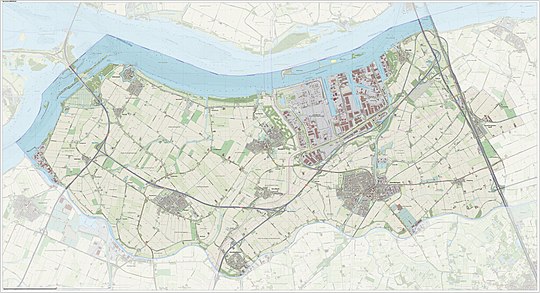
Dutch Topographic map of the municipality of Moerdijk, June 2015
The village of Moerdijk is one of the smaller villages of the municipality. Population as of 2002 is 1,205. Moerdijk is however a well-known name in the Netherlands, because of the large Moerdijk industrial area, with a large power plant, and because of the well-known Moerdijk bridges (highway and railway bridges) across the Hollands Diep. This was the last bridge available for the retreat from the vital Scheldt Estuary of the rapidly collapsing German defences near Antwerp in World War II. (Noteworthy as well, the Moerdijk bridges were one of the first targets of guided, or "smart bombs"- by American heavy bombers in late 1944.)
...
Wikipedia


